
Carte topographique Crowsnest
Carte interactive
Cliquez sur la carte pour afficher l’altitude.
À propos de cette carte
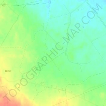
Nom : Carte topographique Crowsnest, altitude, relief.
Altitude moyenne : 67 m
Altitude minimum : 48 m
Altitude maximum : 94 m
Autres cartes topographiques
Cliquez sur une carte pour visualiser sa topographie, son altitude et son relief.
Cleggan
Cleggan, Conamara Municipal District, County Galway, Connacht, H71 HY36, Ireland
Altitude moyenne : 29 m
Lough Loung
Lough Loung, Ballynakill ED, Ballinasloe Municipal District, County Galway, Connacht, Ireland
Altitude moyenne : 65 m
Aughrim
Aughrim, Ballinasloe Municipal District, County Galway, Connacht, Ireland
Altitude moyenne : 68 m
Loughrea
Loughrea, Loughrea Urban ED, Loughrea Municipal District, County Galway, Connacht, Ireland
Altitude moyenne : 88 m
Athenry-Oranmore Municipal District
Athenry-Oranmore Municipal District, County Galway, Connacht, Ireland
Altitude moyenne : 43 m
Galway Bay
Galway Bay, County Galway, Connacht, Ireland
Altitude moyenne : 35 m
Galway City
Ireland > County Galway > Galway City
Galway City, County Galway, Connacht, Ireland
Altitude moyenne : 15 m
Highpark
Highpark, Grange ED, Loughrea Municipal District, County Galway, Connacht, Ireland
Altitude moyenne : 102 m