
Faire un don
Équipez-vous pour votre prochaine aventure :
En tant que Partenaire Amazon, ce site perçoit une commission sur les achats éligibles sans surcoût pour vous.
Carte topographique Deißlingen
Cliquez sur la carte pour afficher l’altitude.
Faire un don
Équipez-vous pour votre prochaine aventure :
En tant que Partenaire Amazon, ce site perçoit une commission sur les achats éligibles sans surcoût pour vous.
Deißlingen
The municipality (Gemeinde) of Deißlingen covers 32.15 square kilometers (12.41 sq mi) of the Rottweil district of Baden-Württemberg, which assigns Deißlingen to the metropolitan area of Villingen-Schwenningen, Tuttlingen, and Rottweil. Deißlingen is physically located in a transitional landscape between the muschelkalk-keuper plateaus of the Upper Gäu [de] to the north, the Swabian Jura to the east, and the Baar to the south. Elevation above sea level in the municipal area ranges from a high of 753 meters (2,470 ft) Normalnull (NN) at the border with Tuttlingen district to a low of 574 meters (1,883 ft) NN on the Neckar as it forms the border with Rottweil.
Faire un don
Équipez-vous pour votre prochaine aventure :
En tant que Partenaire Amazon, ce site perçoit une commission sur les achats éligibles sans surcoût pour vous.
À propos de cette carte
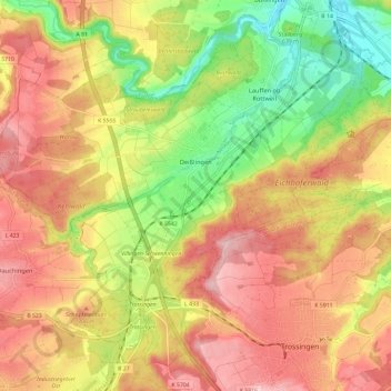
Nom : Carte topographique Deißlingen, altitude, relief.
Altitude moyenne : 669 m
Altitude minimum : 563 m
Altitude maximum : 756 m
Faire un don
Équipez-vous pour votre prochaine aventure :
En tant que Partenaire Amazon, ce site perçoit une commission sur les achats éligibles sans surcoût pour vous.