
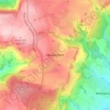
Carte topographique Hewelsfield
Carte interactive
Cliquez sur la carte pour afficher l’altitude.
À propos de cette carte
Nom : Carte topographique Hewelsfield, altitude, relief.
Altitude moyenne : 161 m
Altitude minimum : 32 m
Altitude maximum : 249 m
Autres cartes topographiques
Cliquez sur une carte pour visualiser sa topographie, son altitude et son relief.
Newnham on Severn
United Kingdom > England > Gloucestershire > Forest of Dean District
Newnham on Severn, Forest of Dean District, Gloucestershire, England, GL14 1AJ, United Kingdom
Altitude moyenne : 55 m
Viney Hill
United Kingdom > England > Gloucestershire > Forest of Dean District > Viney
Viney Hill, West Dean, Viney, Forest of Dean District, Gloucestershire, England, GL15 4NU, United Kingdom
Altitude moyenne : 91 m
Bromsberrow
United Kingdom > England > Gloucestershire > Forest of Dean District
Bromsberrow, Forest of Dean District, Gloucestershire, England, HR8 1RU, United Kingdom
Altitude moyenne : 75 m
Glasshouse
United Kingdom > England > Gloucestershire > Forest of Dean District > May Hill
Glasshouse, Taynton, May Hill, Forest of Dean District, Gloucestershire, England, GL17 0NW, United Kingdom
Altitude moyenne : 110 m
Cannop
United Kingdom > England > Gloucestershire > Forest of Dean District
Cannop, West Dean, Forest of Dean District, Gloucestershire, England, GL16 7EQ, United Kingdom
Altitude moyenne : 157 m
Ruardean Woodside
United Kingdom > England > Gloucestershire > Forest of Dean District > Ruardean > Ruardean Woodside
Ruardean Woodside, Ruardean, Forest of Dean District, Gloucestershire, England, GL17 9YF, United Kingdom
Altitude moyenne : 186 m
Dursley Cross
United Kingdom > England > Gloucestershire > Forest of Dean District > May Hill > Dursley Cross
Dursley Cross, Longhope, May Hill, Forest of Dean District, Gloucestershire, England, GL17 0NE, United Kingdom
Altitude moyenne : 126 m
Westbury-on-Severn
United Kingdom > England > Gloucestershire > Forest of Dean District
Westbury-on-Severn, Forest of Dean District, Gloucestershire, England, GL14 1PA, United Kingdom
Altitude moyenne : 17 m
Wigpool Green
United Kingdom > England > Gloucestershire > Forest of Dean District > Puddlebrook > Wigpool Green
Wigpool Green, Mitcheldean, Puddlebrook, Forest of Dean District, Gloucestershire, England, GL17 0JH, United Kingdom
Altitude moyenne : 173 m
Sling
United Kingdom > England > Gloucestershire > Forest of Dean District
Sling, Forest of Dean District, Gloucestershire, England, GL16 8LH, United Kingdom
Altitude moyenne : 174 m
Coalway
United Kingdom > England > Gloucestershire > Forest of Dean District
Coalway, Forest of Dean District, Gloucestershire, England, GL16 7JQ, United Kingdom
Altitude moyenne : 181 m
Brockweir
United Kingdom > England > Gloucestershire > Forest of Dean District
Brockweir, Forest of Dean District, Gloucestershire, England, NP16 7NG, United Kingdom
Altitude moyenne : 145 m