
Carte topographique Washington, D.C.
Carte interactive
Cliquez sur la carte pour afficher l’altitude.
À propos de cette carte
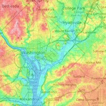
Nom : Carte topographique Washington, D.C., altitude, relief.
Lieu : Washington, D.C., United States of America (38.79163 -77.11977 38.99585 -76.90937)
Altitude moyenne : 49 m
Altitude minimum : -3 m
Altitude maximum : 129 m
The highest natural elevation in the District is 409 feet (125 m) above sea level at Fort Reno Park in upper northwest Washington. The lowest point is sea level at the Potomac River. The geographic center of Washington is near the intersection of 4th and L Streets NW.
Autres cartes topographiques
Cliquez sur une carte pour visualiser sa topographie, son altitude et son relief.
Washington, D.C.
United States of America > Washington, D.C. > Washington, D.C.
Washington, D.C., Washington, Washington, D.C., 20500, United States of America
Altitude moyenne : 63 m