
Carte topographique El Espino
Carte interactive
Cliquez sur la carte pour afficher l’altitude.
À propos de cette carte
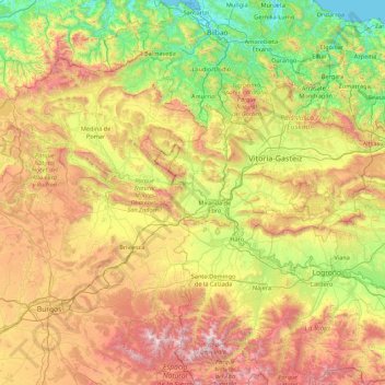
Nom : Carte topographique El Espino, altitude, relief.
Lieu : El Espino, Castile and León, 09219, Spain (42.08743 -3.68777 43.36743 -2.40777)
Altitude moyenne : 732 m
Altitude minimum : -1 m
Altitude maximum : 2 163 m
Autres cartes topographiques
Cliquez sur une carte pour visualiser sa topographie, son altitude et son relief.
Burgos
Spain > Castile and León > Burgos
Burgos, Alfoz de Burgos, Burgos, Castile and León, Spain
Altitude moyenne : 907 m
Buenavista
Spain > Castile and León > Buenavista > Buenavista
Buenavista, Tierra de Alba, Salamanca, Castile and León, 37789, Spain
Altitude moyenne : 924 m
Dehesa de Perosín
Spain > Castile and León > Peñaparda
Dehesa de Perosín, Peñaparda, Comarca de Ciudad Rodrigo, Salamanca, Castile and León, 37524, Spain
Altitude moyenne : 862 m
Puebla de Lillo
Spain > Castile and León > Puebla de Lillo
Puebla de Lillo, León, Castile and León, 24855, Spain
Altitude moyenne : 1 461 m
Contreras
Spain > Castile and León > Contreras
Contreras, Sierra de la Demanda, Burgos, Castile and León, Spain
Altitude moyenne : 1 089 m