
Carte topographique Villars-sur-Ollon
Carte interactive
Cliquez sur la carte pour afficher l’altitude.
À propos de cette carte
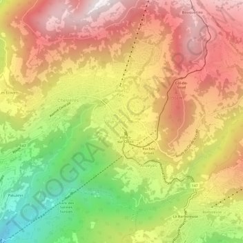
Nom : Carte topographique Villars-sur-Ollon, altitude, relief.
Lieu : Villars-sur-Ollon, Olun, District d'Aigle, Waadt, 1884, Schweiz (46.27776 7.03533 46.31776 7.07533)
Altitude moyenne : 1 293 m
Altitude minimum : 588 m
Altitude maximum : 1 871 m
Autres cartes topographiques
Cliquez sur une carte pour visualiser sa topographie, son altitude et son relief.
Rhonetal
Schweiz > Waadt > District d'Aigle
Rhonetal, District d'Aigle, Waadt, Schweiz
Altitude moyenne : 1 378 m
Tour d'Aï
Schweiz > Waadt > District d'Aigle > Leysin
Tour d'Aï, Leysin, District d'Aigle, Waadt, 1854, Schweiz
Altitude moyenne : 1 844 m
Les Diablerets
Schweiz > Waadt > District d'Aigle > Ormont-Dessus
Les Diablerets, Ormont-Dessus, District d'Aigle, Waadt, 1865, Schweiz
Altitude moyenne : 1 453 m
Olun
Schweiz > Waadt > District d'Aigle
Olun, District d'Aigle, Waadt, Schweiz
Altitude moyenne : 898 m