
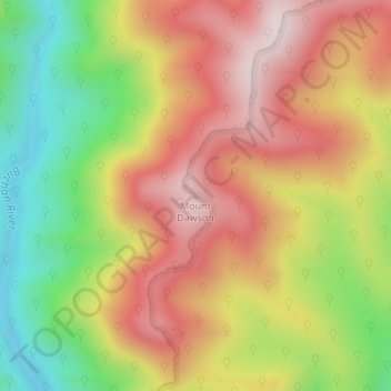
Carte topographique Mount Dawson
Carte interactive
Cliquez sur la carte pour afficher l’altitude.
À propos de cette carte
Nom : Carte topographique Mount Dawson, altitude, relief.
Altitude moyenne : 435 m
Altitude minimum : 147 m
Altitude maximum : 688 m
Autres cartes topographiques
Cliquez sur une carte pour visualiser sa topographie, son altitude et son relief.
Parliament Gardens
Australia > Victoria > Melbourne
Parliament Gardens, East Melbourne, Melbourne, City of Melbourne, Victoria, 3002, Australia
Altitude moyenne : 32 m
Melbourne Water Pipe Reserve
Australia > Victoria > Melbourne
Melbourne Water Pipe Reserve, Burwood East, Melbourne, City of Whitehorse, Victoria, Australia
Altitude moyenne : 119 m
Science Garden
Australia > Victoria > Melbourne
Science Garden, Greenvale, Melbourne, City of Hume, Victoria, 3059, Australia
Altitude moyenne : 174 m
Melbourne Water Retarding Basin
Australia > Victoria > Melbourne
Melbourne Water Retarding Basin, Carrum Downs, Melbourne, City of Frankston, Victoria, Australia
Altitude moyenne : 22 m
Doncaster Hill
Australia > Victoria > Melbourne
Doncaster Hill, Melbourne, City of Manningham, Victoria, 3108, Australia
Altitude moyenne : 86 m
City of Greater Geelong
City of Greater Geelong, Victoria, Australia
Altitude moyenne : 77 m
Warrnambool
Australia > Victoria > Warrnambool
Warrnambool, City of Warrnambool, Victoria, 3280, Australia
Altitude moyenne : 19 m
Mount Dandenong
Mount Dandenong, Shire of Yarra Ranges, Victoria, 3767, Australia
Altitude moyenne : 413 m
Rural City of Mildura
Rural City of Mildura, Victoria, Australia
Altitude moyenne : 65 m
Wilsons Promontory
Wilsons Promontory, Shire of South Gippsland, Gippsland, Victoria, Australia
Altitude moyenne : 28 m
Wingan River
Wingan River, Shire of East Gippsland, Gippsland, Victoria, Australia
Altitude moyenne : 131 m
Manifold Heights
Australia > Victoria > Geelong
Manifold Heights, Geelong, City of Greater Geelong, Barwon South West, Victoria, 3218, Australia
Altitude moyenne : 41 m
Mount Feathertop
Mount Feathertop, Alpine Shire, Hume, Victoria, Australia
Altitude moyenne : 1 533 m
Hattah - Kulkyne National Park
Australia > Victoria > Colignan
Hattah - Kulkyne National Park, Reed Road, Hattah, Colignan, Rural City of Mildura, Loddon Mallee, Victoria, Australia
Altitude moyenne : 51 m
Wilsons Promontory National Park
Wilsons Promontory National Park, Vereker Outlook, Wilsons Promontory, Shire of South Gippsland, Gippsland, Victoria, Australia
Altitude moyenne : 32 m
Mount Fraser
Mount Fraser, Shire of Mitchell, Hume, Victoria, 3753, Australia
Altitude moyenne : 309 m
Spring Hill
Spring Hill, Shire of Mount Alexander, Loddon Mallee, Victoria, Australia
Altitude moyenne : 421 m
Croajingolong National Park
Croajingolong National Park, Lake Barracotta Link Track, Genoa, Shire of East Gippsland, Gippsland, Victoria, Australia
Altitude moyenne : 50 m
Narre Warren
Australia > Victoria > Harkaway
Narre Warren, Harkaway, City of Casey, Victoria, Australia
Altitude moyenne : 42 m
Basalt Lake
Australia > Victoria > Harkaway
Basalt Lake, Board Walk, Berwick, Harkaway, City of Casey, Victoria, 3806, Australia
Altitude moyenne : 76 m
Mount Buangor State Park
Mount Buangor State Park, Saddle Road, Buangor, Shire of Pyrenees, Grampians, Victoria, VIC 3375, Australia
Altitude moyenne : 588 m