
Carte topographique Etna
Carte interactive
Cliquez sur la carte pour afficher l’altitude.
À propos de cette carte
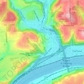
Nom : Carte topographique Etna, altitude, relief.
Lieu : Etna, Allegheny County, Pennsylvania, United States (40.48750 -79.95828 40.50861 -79.93819)
Altitude moyenne : 274 m
Altitude minimum : 218 m
Altitude maximum : 360 m
Etna has a beautiful hilly topography with dramatic exposed shale rock as you enter Etna borough off of Route 28 from Pittsburgh. The downtown area is a quaint main street named one of the best main streets in Pennsylvania in 2021.