
Faire un don
Équipez-vous pour votre prochaine aventure :
En tant que Partenaire Amazon, ce site perçoit une commission sur les achats éligibles sans surcoût pour vous.
Carte topographique Paloquemao
Cliquez sur la carte pour afficher l’altitude.
Faire un don
Équipez-vous pour votre prochaine aventure :
En tant que Partenaire Amazon, ce site perçoit une commission sur les achats éligibles sans surcoût pour vous.
À propos de cette carte
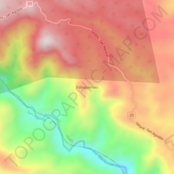
Nom : Carte topographique Paloquemao, altitude, relief.
Altitude moyenne : 2 152 m
Altitude minimum : 1 742 m
Altitude maximum : 2 458 m
Faire un don
Équipez-vous pour votre prochaine aventure :
En tant que Partenaire Amazon, ce site perçoit une commission sur les achats éligibles sans surcoût pour vous.
Autres cartes topographiques
Cliquez sur une carte pour visualiser sa topographie, son altitude et son relief.
Parque Nacional Natural Puracé
El parque nacional natural Puracé se encuentra en la reserva de biosfera del cinturón andino, región del Macizo Colombiano perteneciente a la cordillera Central de los Andes en Colombia. Su superficie hace parte de los departamentos del Cauca y del Huila. Su altitud es de 4646 msnm; en el parque se…
Altitude moyenne : 2 708 m