
Carte topographique South Westchester Meadow
Carte interactive
Cliquez sur la carte pour afficher l’altitude.
À propos de cette carte
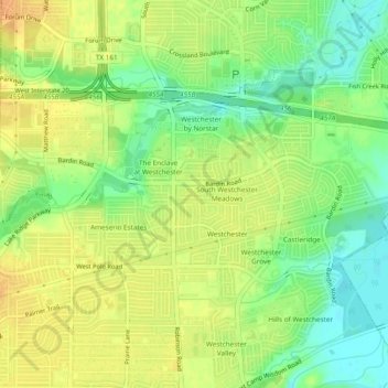
Nom : Carte topographique South Westchester Meadow, altitude, relief.
Altitude moyenne : 158 m
Altitude minimum : 140 m
Altitude maximum : 172 m
Autres cartes topographiques
Cliquez sur une carte pour visualiser sa topographie, son altitude et son relief.
Westchester Valley
United States > Texas > Dallas County > Grand Prairie
Westchester Valley, Grand Prairie, Dallas County, Texas, 75054, United States
Altitude moyenne : 158 m
Joe Pool Lake
United States > Texas > Dallas County > Grand Prairie
Joe Pool Lake, Grand Prairie, Dallas County, Texas, 75054, United States
Altitude moyenne : 186 m
South Westchester Meadows
United States > Texas > Dallas County > Grand Prairie
South Westchester Meadows, Grand Prairie, Dallas County, Texas, 75052, United States
Altitude moyenne : 156 m
Shady Grove
United States > Texas > Dallas County > Grand Prairie
Shady Grove, Grand Prairie, Dallas County, Texas, 75050, United States
Altitude moyenne : 146 m
Lakeview
United States > Texas > Dallas County > Grand Prairie
Lakeview, Grand Prairie, Dallas County, Texas, 75051, United States
Altitude moyenne : 149 m
Grand Prairie
United States > Texas > Dallas County > Grand Prairie
Grand Prairie, Dallas County, Texas, 75051, United States
Altitude moyenne : 170 m