
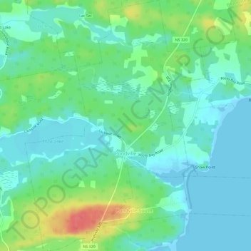
Carte topographique Pondville
Carte interactive
Cliquez sur la carte pour afficher l’altitude.
À propos de cette carte
Nom : Carte topographique Pondville, altitude, relief.
Altitude moyenne : 17 m
Altitude minimum : -5 m
Altitude maximum : 61 m
Autres cartes topographiques
Cliquez sur une carte pour visualiser sa topographie, son altitude et son relief.
Port Royal
Canada > Nova Scotia > Municipality of the County of Richmond
Port Royal, Municipality of the County of Richmond, Richmond County, Nova Scotia, Canada
Altitude moyenne : 9 m
Barren Hill
Canada > Nova Scotia > Municipality of the County of Richmond
Barren Hill, Municipality of the County of Richmond, Richmond County, Nova Scotia, Canada
Altitude moyenne : 58 m
French Cove
Canada > Nova Scotia > Municipality of the County of Richmond
French Cove, Municipality of the County of Richmond, Richmond County, Nova Scotia, Canada
Altitude moyenne : 33 m
Irish Cove
Canada > Nova Scotia > Municipality of the County of Richmond
Irish Cove, Municipality of the County of Richmond, Richmond County, Nova Scotia, Canada
Altitude moyenne : 77 m
Soldiers Cove
Canada > Nova Scotia > Municipality of the County of Richmond
Soldiers Cove, Municipality of the County of Richmond, Richmond County, Nova Scotia, Canada
Altitude moyenne : 37 m
Petit-de-Grat
Canada > Nova Scotia > Municipality of the County of Richmond
Petit-de-Grat, Municipality of the County of Richmond, Richmond County, Nova Scotia, B0E 2L0, Canada
Altitude moyenne : 8 m
Lower L'Ardoise
Canada > Nova Scotia > Municipality of the County of Richmond
Lower L'Ardoise, Municipality of the County of Richmond, Richmond County, Nova Scotia, B0E 1W0, Canada
Altitude moyenne : 22 m
Sampson Lake
Canada > Nova Scotia > Municipality of the County of Richmond > Louisdale
Sampson Lake, Louisdale, Municipality of the County of Richmond, Richmond County, Nova Scotia, B0E 1V0, Canada
Altitude moyenne : 7 m
Glasgow Point
Canada > Nova Scotia > Municipality of the County of Richmond
Glasgow Point, Municipality of the County of Richmond, Richmond County, Nova Scotia, Canada
Altitude moyenne : 10 m
Bee Island
Canada > Nova Scotia > Municipality of the County of Richmond
Bee Island, Municipality of the County of Richmond, Richmond County, Nova Scotia, Canada
Altitude moyenne : 43 m
Arichat
Canada > Nova Scotia > Municipality of the County of Richmond
Arichat, Municipality of the County of Richmond, Richmond County, Nova Scotia, B0E 1A0, Canada
Altitude moyenne : 12 m
Crow Island
Canada > Nova Scotia > Municipality of the County of Richmond > Poulamon
Crow Island, Poulamon, Municipality of the County of Richmond, Richmond County, Nova Scotia, B0E 1K0, Canada
Altitude moyenne : 40 m
Bras d'Or Lake
Canada > Nova Scotia > Municipality of the County of Richmond > Red Islands
Bras d'Or Lake, Red Islands, Municipality of the County of Richmond, Richmond County, Nova Scotia, Canada
Altitude moyenne : 29 m
St. Esprit
Canada > Nova Scotia > Municipality of the County of Richmond
St. Esprit, Municipality of the County of Richmond, Richmond County, Nova Scotia, Canada
Altitude moyenne : 44 m
St. Marys
Canada > Nova Scotia > Municipality of the County of Richmond > St. Marys
St. Marys, Municipality of the County of Richmond, Richmond County, Nova Scotia, Canada
Altitude moyenne : 9 m
Barachois Pond
Canada > Nova Scotia > Municipality of the County of Richmond > Arichat
Barachois Pond, Arichat, Municipality of the County of Richmond, Richmond County, Nova Scotia, B0E 1A0, Canada
Altitude moyenne : 16 m
D'Escousse
Canada > Nova Scotia > Municipality of the County of Richmond
D'Escousse, Municipality of the County of Richmond, Richmond County, Nova Scotia, B0E 1K0, Canada
Altitude moyenne : 13 m
Fourchu
Canada > Nova Scotia > Municipality of the County of Richmond
Fourchu, Municipality of the County of Richmond, Richmond County, Nova Scotia, Canada
Altitude moyenne : 5 m
West Bay
Canada > Nova Scotia > Municipality of the County of Richmond
West Bay, Municipality of the County of Richmond, Richmond County, Nova Scotia, Canada
Altitude moyenne : 55 m