
Carte topographique Ormeau Park
Carte interactive
Cliquez sur la carte pour afficher l’altitude.
À propos de cette carte
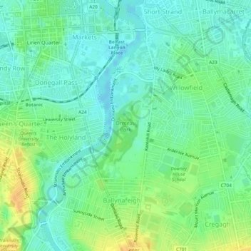
Nom : Carte topographique Ormeau Park, altitude, relief.
Altitude moyenne : 11 m
Altitude minimum : -2 m
Altitude maximum : 29 m
Autres cartes topographiques
Cliquez sur une carte pour visualiser sa topographie, son altitude et son relief.
Derry/Londonderry
United Kingdom > Northern Ireland > County Londonderry
Derry/Londonderry, County Borough of Londonderry, County Londonderry, Northern Ireland, BT48 6BU, United Kingdom
Altitude moyenne : 88 m
Newtownabbey
United Kingdom > Northern Ireland > County Antrim
Newtownabbey, County Antrim, Northern Ireland, BT36 6UN, United Kingdom
Altitude moyenne : 100 m
Randalstown
United Kingdom > Northern Ireland > County Antrim
Randalstown, County Antrim, Northern Ireland, BT41 3AD, United Kingdom
Altitude moyenne : 57 m
Larne
United Kingdom > Northern Ireland > County Antrim
Larne, County Antrim, Northern Ireland, BT40 1JS, United Kingdom
Altitude moyenne : 54 m
Hillhall
United Kingdom > Northern Ireland > County Down
Hillhall, County Down, Northern Ireland, BT27 5JA, United Kingdom
Altitude moyenne : 61 m
Belfast
United Kingdom > Northern Ireland > County Antrim
Belfast, County Antrim, Northern Ireland, United Kingdom
Altitude moyenne : 92 m
Tandragee
United Kingdom > Northern Ireland > County Armagh
Tandragee, County Armagh, Ulster, Northern Ireland, BT62 2DG, United Kingdom
Altitude moyenne : 50 m
County Tyrone
United Kingdom > Northern Ireland
County Tyrone, Ulster, Northern Ireland, United Kingdom
Altitude moyenne : 128 m
Carrickfergus
United Kingdom > Northern Ireland > County Antrim
Carrickfergus, County Antrim, Ulster, Northern Ireland, BT38 7AF, United Kingdom
Altitude moyenne : 49 m
Benraw
United Kingdom > Northern Ireland > County Down
Benraw, County Down, Ulster, Northern Ireland, United Kingdom
Altitude moyenne : 182 m
Armagh
United Kingdom > Northern Ireland > County Armagh > Milford
Armagh, Milford, County Armagh, Ulster, Northern Ireland, United Kingdom
Altitude moyenne : 100 m
Newry
United Kingdom > Northern Ireland > County Down
Newry, County Down, Northern Ireland, United Kingdom
Altitude moyenne : 73 m
Backwood
United Kingdom > Northern Ireland
Backwood, Ulster, Northern Ireland, United Kingdom
Altitude moyenne : 81 m
Blaney
United Kingdom > Northern Ireland
Blaney, Blaney East, Fermanagh and Omagh District, Northern Ireland, United Kingdom
Altitude moyenne : 84 m
Ulster
United Kingdom > Northern Ireland
Ulster, Northern Ireland, United Kingdom
Altitude moyenne : 71 m
Banbridge
United Kingdom > Northern Ireland > County Down
Banbridge, County Down, Northern Ireland, BT32 3DB, United Kingdom
Altitude moyenne : 90 m
Belcoo
United Kingdom > Northern Ireland > County Fermanagh > Belcoo
Belcoo, County Fermanagh, Northern Ireland, BT93 5FB, United Kingdom
Altitude moyenne : 86 m
Pig Island
United Kingdom > Northern Ireland
Pig Island, Northern Ireland, United Kingdom
Altitude moyenne : 8 m
Boho
United Kingdom > Northern Ireland > County Fermanagh
Boho, County Fermanagh, Northern Ireland, BT74 8BZ, United Kingdom
Altitude moyenne : 102 m
Lough Neagh
United Kingdom > Northern Ireland > Lisburn
Lough Neagh, Lisburn, County Antrim, Northern Ireland, United Kingdom
Altitude moyenne : 29 m
Antrim
United Kingdom > Northern Ireland > County Antrim > Antrim
Antrim, County Antrim, Northern Ireland, BT41 4AR, United Kingdom
Altitude moyenne : 50 m
Moneyscalp
United Kingdom > Northern Ireland
Moneyscalp, Northern Ireland, United Kingdom
Altitude moyenne : 147 m
Carryduff
United Kingdom > Northern Ireland > County Down > Carryduff
Carryduff, County Down, Northern Ireland, BT8 8DN, United Kingdom
Altitude moyenne : 110 m
Spring Farm
United Kingdom > Northern Ireland
Spring Farm, Northern Ireland, United Kingdom
Altitude moyenne : 42 m
Ballymena
United Kingdom > Northern Ireland > County Antrim > Ballymena
Ballymena, County Antrim, Northern Ireland, BT43 6AH, United Kingdom
Altitude moyenne : 74 m
Stoneyford
United Kingdom > Northern Ireland > Lisburn > Stoneyford
Stoneyford, Lisburn, County Antrim, Northern Ireland, BT28 3SU, United Kingdom
Altitude moyenne : 159 m
Old Mill
United Kingdom > Northern Ireland > County Antrim > Ballygally > Old Mill
Old Mill, Ballygally, County Antrim, Northern Ireland, BT40 2RX, United Kingdom
Altitude moyenne : 47 m
Comber
United Kingdom > Northern Ireland > Comber
Comber, County Down, Northern Ireland, BT23 5DZ, United Kingdom
Altitude moyenne : 36 m
Dungannon
United Kingdom > Northern Ireland > Dungannon
Dungannon, County Tyrone, Northern Ireland, BT71 7AA, United Kingdom
Altitude moyenne : 76 m
Bushmills
United Kingdom > Northern Ireland > County Antrim
Bushmills, County Antrim, Ulster, Northern Ireland, BT57 8QB, United Kingdom
Altitude moyenne : 42 m
Eglinton
United Kingdom > Northern Ireland > Eglinton
Eglinton, County Londonderry, Northern Ireland, BT47 3GY, United Kingdom
Altitude moyenne : 48 m
Malone Lower
United Kingdom > Northern Ireland > Belfast
Malone Lower, Belfast, County Antrim, Northern Ireland, United Kingdom
Altitude moyenne : 15 m
Magherafelt
United Kingdom > Northern Ireland > Magherafelt
Magherafelt, County Londonderry, Northern Ireland, BT45 6EE, United Kingdom
Altitude moyenne : 59 m
Drumanure
United Kingdom > Northern Ireland > Derrygonnelly
Drumanure, Derrygonnelly, County Fermanagh, Northern Ireland, United Kingdom
Altitude moyenne : 67 m
British
United Kingdom > Northern Ireland > Aldergrove
British, Aldergrove, County Antrim, Northern Ireland, BT29 4ZY, United Kingdom
Altitude moyenne : 58 m
Doonan
United Kingdom > Northern Ireland
Doonan, Northern Ireland, United Kingdom
Altitude moyenne : 186 m
Annaghboy
United Kingdom > Northern Ireland > Armagh
Annaghboy, Armagh, County Armagh, Northern Ireland, United Kingdom
Altitude moyenne : 54 m
Rostrevor
United Kingdom > Northern Ireland > Rostrevor
Rostrevor, County Down, Northern Ireland, United Kingdom
Altitude moyenne : 78 m
Trial Bay
United Kingdom > Northern Ireland
Trial Bay, County Fermanagh, Northern Ireland, BT92 9GN, United Kingdom
Altitude moyenne : 50 m
Ballykeel
United Kingdom > Northern Ireland > Ballymena
Ballykeel, Ballymena, County Antrim, Northern Ireland, United Kingdom
Altitude moyenne : 58 m
Ballygawley
United Kingdom > Northern Ireland
Ballygawley, County Londonderry, Northern Ireland, United Kingdom
Altitude moyenne : 40 m
Newry
United Kingdom > Northern Ireland > County Down > Newry
Newry, County Down, Northern Ireland, BT34 1DG, United Kingdom
Altitude moyenne : 129 m
Forth River
United Kingdom > Northern Ireland > Belfast
Forth River, Belfast, County Antrim, Northern Ireland, BT13 3BU, United Kingdom
Altitude moyenne : 73 m
Loughinisland
United Kingdom > Northern Ireland > Loughinisland
Loughinisland, County Down, Northern Ireland, BT24 8RL, United Kingdom
Altitude moyenne : 50 m
County Down
United Kingdom > Northern Ireland
County Down, Northern Ireland, United Kingdom
Altitude moyenne : 65 m
Lisburn
United Kingdom > Northern Ireland > County Antrim
Lisburn, County Antrim, Northern Ireland, BT28 1BJ, United Kingdom
Altitude moyenne : 92 m
Black Mountain
United Kingdom > Northern Ireland > Lisburn
Black Mountain, Lisburn, County Antrim, Northern Ireland, BT11 8BU, United Kingdom
Altitude moyenne : 232 m
Seaforde
United Kingdom > Northern Ireland > Clough
Seaforde, Clough, County Down, Northern Ireland, BT30 8RE, United Kingdom
Altitude moyenne : 34 m
Roe
United Kingdom > Northern Ireland > Londonderry/Derry
Roe, Londonderry/Derry, County Londonderry, Northern Ireland, BT47 4LG, United Kingdom
Altitude moyenne : 83 m
Lisdrumgullion
United Kingdom > Northern Ireland > Newry
Lisdrumgullion, Newry, County Down, Northern Ireland, BT35 6BH, United Kingdom
Altitude moyenne : 41 m