
Carte topographique Tepic
Carte interactive
Cliquez sur la carte pour afficher l’altitude.
À propos de cette carte
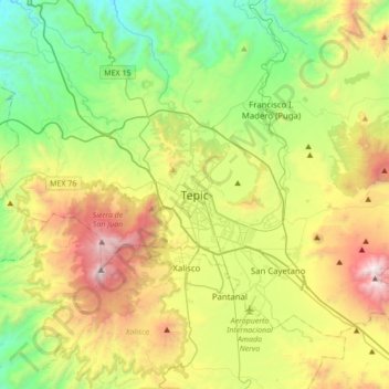
Nom : Carte topographique Tepic, altitude, relief.
Lieu : Tepic, Nayarit, 63000, Mexico (21.35192 -105.05159 21.67192 -104.73159)
Altitude moyenne : 921 m
Altitude minimum : 147 m
Altitude maximum : 2 317 m
Located in the central part of the state, it stands at an altitude of 915 metres (3,002 ft) above sea level, on the banks of the Río Mololoa and the Río Tepic, approximately 225 kilometres (140 mi) north-west of Guadalajara, Jalisco. Nearby are the extinct Sangangüey volcano and its crater lake. Tepic is the primary urban center of this rich agricultural region; major crops include sugarcane, tobacco and citrus fruits.