
Carte topographique Graz
Carte interactive
Cliquez sur la carte pour afficher l’altitude.
À propos de cette carte
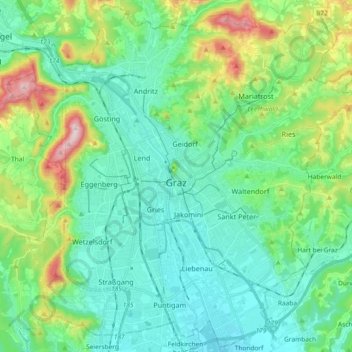
Nom : Carte topographique Graz, altitude, relief.
Lieu : Graz, Styria, Austria (47.01189 15.34971 47.13450 15.53420)
Altitude moyenne : 426 m
Altitude minimum : 326 m
Altitude maximum : 749 m
Graz is situated on both sides of the river Mur in southeast Austria. It is about 150 km (93 mi) southwest of Vienna (Wien). The nearest larger urban centre is Maribor (Marburg) in Slovenia, which is about 50 km (31 mi) to the south. Graz is the capital of Styria and the largest city in the province, a green and heavily forested region on the eastern edge of the Alps. It is located in the Graz Basin and surrounded by mountains and hills to the north, east and west. The city centre sits at an elevation of 353 m (1,158 ft), the highest point is Plabutsch mountain with 754 m (2,474 ft) at the western border. The mountain Schöckl is just a few kilometres to the north and surmounts the city by 1,100 m (3,600 ft).
Autres cartes topographiques
Cliquez sur une carte pour visualiser sa topographie, son altitude et son relief.
Murau
Austria > Styria > Bezirk Murau
Murau, Bezirk Murau, Styria, 8850, Austria
Altitude moyenne : 1 285 m
Schönberg
Austria > Styria > Bezirk Murtal > Flatschach
Schönberg, Flatschach, Spielberg, Bezirk Murtal, Styria, 8720, Austria
Altitude moyenne : 806 m
Schladming
Austria > Styria > Schladming
Schladming, Politische Expositur Gröbming, Bezirk Liezen, Styria, 8970, Austria
Altitude moyenne : 1 552 m
Feldkirchen bei Graz
Austria > Styria > Feldkirchen bei Graz
Feldkirchen bei Graz, Graz-Umgebung, Styria, 8073, Austria
Altitude moyenne : 335 m
Voitsberg
Austria > Styria > Bezirk Voitsberg
Voitsberg, Bezirk Voitsberg, Styria, 8570, Austria
Altitude moyenne : 480 m
Deutschlandsberg
Austria > Styria > Deutschlandsberg
Deutschlandsberg, Styria, Austria
Altitude moyenne : 614 m