
Carte topographique Bathgate
Carte interactive
Cliquez sur la carte pour afficher l’altitude.
À propos de cette carte
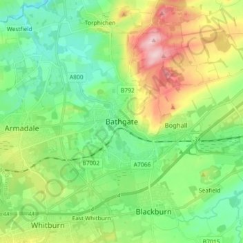
Nom : Carte topographique Bathgate, altitude, relief.
Lieu : Bathgate, West Lothian, Scotland, EH48 1PA, United Kingdom (55.86092 -3.68148 55.94092 -3.60148)
Altitude moyenne : 167 m
Altitude minimum : 97 m
Altitude maximum : 311 m
In the 1846 book A Topographical Dictionary of Scotland, Samuel Lewis writes:
Autres cartes topographiques
Cliquez sur une carte pour visualiser sa topographie, son altitude et son relief.
Livingston
United Kingdom > Scotland > West Lothian
Livingston, West Lothian, Scotland, EH54 6HS, United Kingdom
Altitude moyenne : 158 m