
Carte topographique Poços de Caldas
Carte interactive
Cliquez sur la carte pour afficher l’altitude.
À propos de cette carte
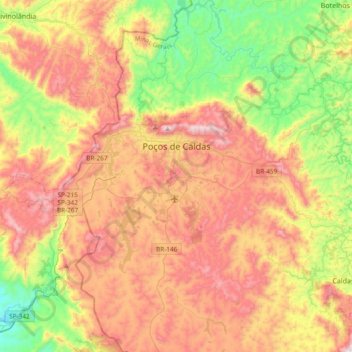
Nom : Carte topographique Poços de Caldas, altitude, relief.
Altitude moyenne : 1 188 m
Altitude minimum : 754 m
Altitude maximum : 1 686 m
It lies on the boundary of the state of São Paulo at 1186 meters elevation and is the main socio-economic nucleus of its region, having an area of 547 km2 (85 km2 urban and 459 km2 rural) in the municipality.