
Carte topographique Braemar Hill
Carte interactive
Cliquez sur la carte pour afficher l’altitude.
À propos de cette carte
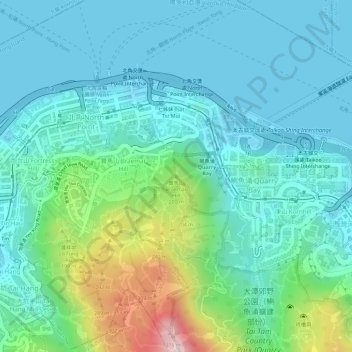
Nom : Carte topographique Braemar Hill, altitude, relief.
Lieu : Braemar Hill, Hong Kong Island, Hong Kong, 000000, China (22.28637 114.20639 22.28647 114.20649)
Altitude moyenne : 89 m
Altitude minimum : 0 m
Altitude maximum : 388 m
Autres cartes topographiques
Cliquez sur une carte pour visualiser sa topographie, son altitude et son relief.
Pok Fu Lam Reservoir
China > Hong Kong > Hong Kong Island
Pok Fu Lam Reservoir, Telegraph Bay, Pok Fu Lam, Southern District, Hong Kong Island, Hong Kong, China
Altitude moyenne : 192 m
Victoria Peak
China > Hong Kong > Hong Kong Island
Victoria Peak, Hong Kong Island, Hong Kong, China
Altitude moyenne : 209 m
Tai Tam Mound Waterfall
China > Hong Kong > Hong Kong Island
Tai Tam Mound Waterfall, Southern District, Hong Kong Island, Hong Kong, China
Altitude moyenne : 150 m
Wong Chuk Hang San Wai
China > Hong Kong > Hong Kong Island > Wong Chuk Hang San Wai
Wong Chuk Hang San Wai, Southern District, Hong Kong Island, Hong Kong, China
Altitude moyenne : 116 m
Sai Wan
China > Hong Kong > Hong Kong Island
Sai Wan, Central and Western District, Hong Kong Island, Hong Kong, China
Altitude moyenne : 81 m
Southern District
China > Hong Kong > Hong Kong Island
Southern District, Hong Kong Island, Hong Kong, China
Altitude moyenne : 36 m
Victoria Park
China > Hong Kong > Hong Kong Island
Victoria Park, Causeway Bay, Wan Chai District, Hong Kong Island, Hong Kong, China
Altitude moyenne : 64 m