
Carte topographique Isle of Portland
Carte interactive
Cliquez sur la carte pour afficher l’altitude.
Isle of Portland
In Museums Without Walls, Jonathan Meades declares that "Portland is a bulky chunk of geological, social, topographical and demographic weirdness. It is the obverse of a beauty spot. 'Beauty' in this construction implies the picturesque. Portland is gloriously bereft of this quality. It is awesome. There is nothing pretty about it."
À propos de cette carte
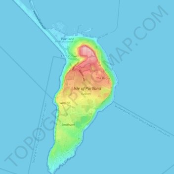
Nom : Carte topographique Isle of Portland, altitude, relief.
Altitude moyenne : 11 m
Altitude minimum : -5 m
Altitude maximum : 145 m
Autres cartes topographiques
Cliquez sur une carte pour visualiser sa topographie, son altitude et son relief.