
Carte topographique Jarabacoa
Carte interactive
Cliquez sur la carte pour afficher l’altitude.
Jarabacoa
Jarabacoa has a Tropical rainforest climate (Köppen climate classification Af ). Due to its high elevation in the interior it has warm days and lower temperatures at nights during most of the year, and temperate days and colder nights during winter months. Because of its climate, visitors have christened Jarabacoa as "The City of Everlasting Spring." Rain is abundant during most all the year.
À propos de cette carte
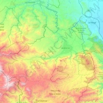
Nom : Carte topographique Jarabacoa, altitude, relief.
Lieu : Jarabacoa, La Vega, 41200, Dominican Republic (18.98326 -70.96021 19.22863 -70.51935)
Altitude moyenne : 947 m
Altitude minimum : 67 m
Altitude maximum : 2 426 m
Autres cartes topographiques
Cliquez sur une carte pour visualiser sa topographie, son altitude et son relief.