
Carte topographique Fermo
Carte interactive
Cliquez sur la carte pour afficher l’altitude.
À propos de cette carte
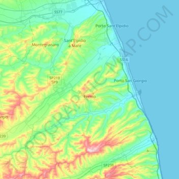
Nom : Carte topographique Fermo, altitude, relief.
Lieu : Fermo, Marche, 63900, Italy (43.10584 13.48920 43.23440 13.82928)
Altitude moyenne : 98 m
Altitude minimum : -2 m
Altitude maximum : 459 m
Fermo is on a hill, the Sabulo, elevation 319 metres (1,047 ft), on a branch from Porto San Giorgio on the Adriatic coast railway.
Autres cartes topographiques
Cliquez sur une carte pour visualiser sa topographie, son altitude et son relief.