
Faire un don
Équipez-vous pour votre prochaine aventure :
En tant que Partenaire Amazon, ce site perçoit une commission sur les achats éligibles sans surcoût pour vous.
Carte topographique Blauen
Cliquez sur la carte pour afficher l’altitude.
Faire un don
Équipez-vous pour votre prochaine aventure :
En tant que Partenaire Amazon, ce site perçoit une commission sur les achats éligibles sans surcoût pour vous.
Blauen
In the 14th century, the mountain was recorded as the Blauwen or Blawen. Matthäus Merian's Topographia Sueviae in the mid-17th century calls it the Hoche Blawen ("High Blawen"). The parish boundary plan of the first Baden state survey of 1769/1770 distinguishes between the Hoch Blauen ("High Blauen") and the Hinter Blauen ("Posterior Blauen"), a 1,087-metre-high (3,565 ft) sub-peak, 700 metres (2,295 ft) north-northeast of the main summit. As the Blauen M[ons] the mountain is shown on the Black Forest map owned by St. Blaise Abbey dating to the year 1788. And in 1845 in the Topographischen Atlas ueber das Grossherzogtum Baden ("Topographic Atlas of the Grand Duchy of Baden") it is called the Blauen, as in other geographical publications of the 19th century. In addition in 19th century travel literature the name Hochblauen occurs frequently, sometimes with the explanation that this is to distinguish it from the Zeller Blauen, 12 kilometres (7 mi) away. In fact, the name Hochblauen was normal for the latter on as shown on topographic maps of the time, while the mountain near Badenweiler can still be found on maps today as the Blauen.
Faire un don
Équipez-vous pour votre prochaine aventure :
En tant que Partenaire Amazon, ce site perçoit une commission sur les achats éligibles sans surcoût pour vous.
À propos de cette carte
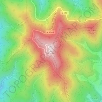
Nom : Carte topographique Blauen, altitude, relief.
Altitude moyenne : 877 m
Altitude minimum : 613 m
Altitude maximum : 1 161 m
Faire un don
Équipez-vous pour votre prochaine aventure :
En tant que Partenaire Amazon, ce site perçoit une commission sur les achats éligibles sans surcoût pour vous.
Autres cartes topographiques
Cliquez sur une carte pour visualiser sa topographie, son altitude et son relief.
Faire un don
Équipez-vous pour votre prochaine aventure :
En tant que Partenaire Amazon, ce site perçoit une commission sur les achats éligibles sans surcoût pour vous.
Faire un don
Équipez-vous pour votre prochaine aventure :
En tant que Partenaire Amazon, ce site perçoit une commission sur les achats éligibles sans surcoût pour vous.
Lörrach (Kernstadt)
Germany > Baden-Württemberg > Landkreis Lörrach > Untertüllingen
Altitude moyenne : 349 m
Lörrach (Kernstadt)
Germany > Baden-Württemberg > Landkreis Lörrach > Untertüllingen
Altitude moyenne : 349 m
Faire un don
Équipez-vous pour votre prochaine aventure :
En tant que Partenaire Amazon, ce site perçoit une commission sur les achats éligibles sans surcoût pour vous.