
Faire un don
Équipez-vous pour votre prochaine aventure :
En tant que Partenaire Amazon, ce site perçoit une commission sur les achats éligibles sans surcoût pour vous.
Carte topographique Enfield
Cliquez sur la carte pour afficher l’altitude.
Faire un don
Équipez-vous pour votre prochaine aventure :
En tant que Partenaire Amazon, ce site perçoit une commission sur les achats éligibles sans surcoût pour vous.
À propos de cette carte
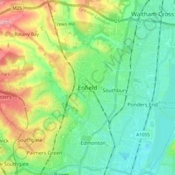
Nom : Carte topographique Enfield, altitude, relief.
Lieu : Enfield, Greater London, England, EN2 6LD, United Kingdom (51.61209 -0.12102 51.69209 -0.04102)
Altitude moyenne : 39 m
Altitude minimum : 7 m
Altitude maximum : 107 m
Faire un don
Équipez-vous pour votre prochaine aventure :
En tant que Partenaire Amazon, ce site perçoit une commission sur les achats éligibles sans surcoût pour vous.
Autres cartes topographiques
Cliquez sur une carte pour visualiser sa topographie, son altitude et son relief.
East Sussex
United Kingdom > England > East Sussex
The chalk uplands of the South Downs occupies the coastal strip between Brighton and Eastbourne. There are two river gaps: the Rivers Ouse and Cuckmere. The Seven Sisters, where the Downs meet the sea, are the remnants of dry valleys cut into the chalk; they end at Beachy Head, 530 feet (162 m) above sea…
Altitude moyenne : 44 m
Leicestershire
United Kingdom > England > Leicestershire
A large part of the north-west of the county, around Coalville, forms part of the new National Forest area extending into Derbyshire and Staffordshire. The highest point of the county is Bardon Hill at 278 m (912 ft), which is also a Marilyn; with other hilly/upland areas of c. 150–200 metres (490–660 ft)…
Altitude moyenne : 98 m
Faire un don
Équipez-vous pour votre prochaine aventure :
En tant que Partenaire Amazon, ce site perçoit une commission sur les achats éligibles sans surcoût pour vous.
Lincolnshire
Lincolnshire has had a comparatively quiet history, being a rural county which was not heavily industrialised and faced little threat of invasion. In the fifth century what would become the county was settled by the invading Angles, who established the Kingdom of Lindsey in the north of the region. The late…
Altitude moyenne : 26 m
Faire un don
Équipez-vous pour votre prochaine aventure :
En tant que Partenaire Amazon, ce site perçoit une commission sur les achats éligibles sans surcoût pour vous.
Sunningdale
United Kingdom > England > Royal Borough of Windsor and Maidenhead
Altitude moyenne : 61 m
Faire un don
Équipez-vous pour votre prochaine aventure :
En tant que Partenaire Amazon, ce site perçoit une commission sur les achats éligibles sans surcoût pour vous.
Surrey
United Kingdom > England > Surrey
The highest elevation in Surrey is Leith Hill near Dorking. It is 295 m (968 ft) above sea level and is the second highest point in southeastern England after Walbury Hill in West Berkshire which is 297 m (974 ft).
Altitude moyenne : 69 m
Faire un don
Équipez-vous pour votre prochaine aventure :
En tant que Partenaire Amazon, ce site perçoit une commission sur les achats éligibles sans surcoût pour vous.
Haslemere
United Kingdom > England > Surrey > Waverley
Many of the roads in the area originated as medieval tracks and owing to the local topography, are narrow, twisting and steep. The principal route through Haslemere is the A286, which connects the town with Godalming and Grayswood (to the north) and with Midhurst (to the south). The A287 runs south from…
Altitude moyenne : 150 m
Faire un don
Équipez-vous pour votre prochaine aventure :
En tant que Partenaire Amazon, ce site perçoit une commission sur les achats éligibles sans surcoût pour vous.
Faire un don
Équipez-vous pour votre prochaine aventure :
En tant que Partenaire Amazon, ce site perçoit une commission sur les achats éligibles sans surcoût pour vous.
Faire un don
Équipez-vous pour votre prochaine aventure :
En tant que Partenaire Amazon, ce site perçoit une commission sur les achats éligibles sans surcoût pour vous.
Faire un don
Équipez-vous pour votre prochaine aventure :
En tant que Partenaire Amazon, ce site perçoit une commission sur les achats éligibles sans surcoût pour vous.
Ashby-de-la-Zouch
United Kingdom > England > Leicestershire > North West Leicestershire
Altitude moyenne : 132 m
Faire un don
Équipez-vous pour votre prochaine aventure :
En tant que Partenaire Amazon, ce site perçoit une commission sur les achats éligibles sans surcoût pour vous.
Bath
United Kingdom > England > Bath and North East Somerset
Bath is in the Avon Valley and is surrounded by limestone hills as it is near the southern edge of the Cotswolds, a designated Area of Outstanding Natural Beauty, and the Mendip Hills rise around 7 miles (11 km) south of the city. The hills that surround and make up the city have a maximum altitude of 781 feet…
Altitude moyenne : 100 m
Faire un don
Équipez-vous pour votre prochaine aventure :
En tant que Partenaire Amazon, ce site perçoit une commission sur les achats éligibles sans surcoût pour vous.
Faire un don
Équipez-vous pour votre prochaine aventure :
En tant que Partenaire Amazon, ce site perçoit une commission sur les achats éligibles sans surcoût pour vous.
Faire un don
Équipez-vous pour votre prochaine aventure :
En tant que Partenaire Amazon, ce site perçoit une commission sur les achats éligibles sans surcoût pour vous.
Faire un don
Équipez-vous pour votre prochaine aventure :
En tant que Partenaire Amazon, ce site perçoit une commission sur les achats éligibles sans surcoût pour vous.
Nottingham Canal
United Kingdom > England > Nottinghamshire > Nottingham > Beeston
Altitude moyenne : 33 m
Faire un don
Équipez-vous pour votre prochaine aventure :
En tant que Partenaire Amazon, ce site perçoit une commission sur les achats éligibles sans surcoût pour vous.
Faire un don
Équipez-vous pour votre prochaine aventure :
En tant que Partenaire Amazon, ce site perçoit une commission sur les achats éligibles sans surcoût pour vous.
Faire un don
Équipez-vous pour votre prochaine aventure :
En tant que Partenaire Amazon, ce site perçoit une commission sur les achats éligibles sans surcoût pour vous.
Faire un don
Équipez-vous pour votre prochaine aventure :
En tant que Partenaire Amazon, ce site perçoit une commission sur les achats éligibles sans surcoût pour vous.
Ludlow
United Kingdom > England > Shropshire
During the 12th century, the planned town of Ludlow was formed, in stages, the town providing a useful source of income for successive Marcher Lords, based on rents, fines, and tolls. They developed the town on a regular grid pattern, although this was adapted somewhat to match the local topography, from the…
Altitude moyenne : 108 m
Faire un don
Équipez-vous pour votre prochaine aventure :
En tant que Partenaire Amazon, ce site perçoit une commission sur les achats éligibles sans surcoût pour vous.
Faire un don
Équipez-vous pour votre prochaine aventure :
En tant que Partenaire Amazon, ce site perçoit une commission sur les achats éligibles sans surcoût pour vous.
Faire un don
Équipez-vous pour votre prochaine aventure :
En tant que Partenaire Amazon, ce site perçoit une commission sur les achats éligibles sans surcoût pour vous.
Faire un don
Équipez-vous pour votre prochaine aventure :
En tant que Partenaire Amazon, ce site perçoit une commission sur les achats éligibles sans surcoût pour vous.
Faire un don
Équipez-vous pour votre prochaine aventure :
En tant que Partenaire Amazon, ce site perçoit une commission sur les achats éligibles sans surcoût pour vous.
Faire un don
Équipez-vous pour votre prochaine aventure :
En tant que Partenaire Amazon, ce site perçoit une commission sur les achats éligibles sans surcoût pour vous.
Northampton
United Kingdom > England > West Northamptonshire
As with the rest of the British Isles, Northampton experiences an oceanic climate with cool summers and mild winters. The official Met Office weather station for Northampton is the Moulton Park Weather Station at the University of Northampton. Situated at an elevation of around 130 m (427 ft) above sea level…
Altitude moyenne : 89 m
Faire un don
Équipez-vous pour votre prochaine aventure :
En tant que Partenaire Amazon, ce site perçoit une commission sur les achats éligibles sans surcoût pour vous.
Ringwood Lake
United Kingdom > England > Derbyshire > Chesterfield > Middlecroft
Altitude moyenne : 88 m
Faire un don
Équipez-vous pour votre prochaine aventure :
En tant que Partenaire Amazon, ce site perçoit une commission sur les achats éligibles sans surcoût pour vous.