
Faire un don
Équipez-vous pour votre prochaine aventure :
En tant que Partenaire Amazon, ce site perçoit une commission sur les achats éligibles sans surcoût pour vous.
Carte topographique Mono
Cliquez sur la carte pour afficher l’altitude.
Faire un don
Équipez-vous pour votre prochaine aventure :
En tant que Partenaire Amazon, ce site perçoit une commission sur les achats éligibles sans surcoût pour vous.
Mono
Mono is a rural community in both geography and character. It has a wide variation in topography, being composed of mostly rolling, tree-covered hills. It holds many streams and creeks which form the headwaters of three rivers - the Humber River, Nottawasaga River and Credit River and most of the town is located on high land relative to the rest of Southern Ontario. This leads to its current slogan of 'the heart of the headwaters'.
Faire un don
Équipez-vous pour votre prochaine aventure :
En tant que Partenaire Amazon, ce site perçoit une commission sur les achats éligibles sans surcoût pour vous.
À propos de cette carte
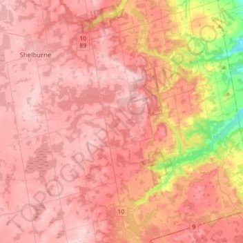
Nom : Carte topographique Mono, altitude, relief.
Lieu : Mono, Dufferin County, Central Ontario, Ontario, Canada (43.92274 -80.17161 44.12324 -79.95119)
Altitude moyenne : 440 m
Altitude minimum : 250 m
Altitude maximum : 530 m
Faire un don
Équipez-vous pour votre prochaine aventure :
En tant que Partenaire Amazon, ce site perçoit une commission sur les achats éligibles sans surcoût pour vous.
Autres cartes topographiques
Cliquez sur une carte pour visualiser sa topographie, son altitude et son relief.
Faire un don
Équipez-vous pour votre prochaine aventure :
En tant que Partenaire Amazon, ce site perçoit une commission sur les achats éligibles sans surcoût pour vous.