
Carte topographique Frostburg
Carte interactive
Cliquez sur la carte pour afficher l’altitude.
À propos de cette carte
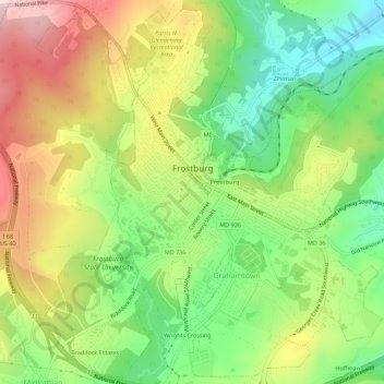
Nom : Carte topographique Frostburg, altitude, relief.
Lieu : Frostburg, Allegany County, Maryland, 21532, United States (39.63471 -78.95116 39.67617 -78.90082)
Altitude moyenne : 620 m
Altitude minimum : 456 m
Altitude maximum : 822 m
Due to its average elevation of 2,000 feet (610 m) above sea level and location near the Allegheny Front, Frostburg has a colder, wetter climate than much of the rest of the state, and falls in USDA hardiness zone 6b. Under the Köppen climate classification, it has a humid continental climate (Dfb), with cold, snowy winters, and warm, humid summers. The daily mean temperature ranges from 26.0 °F (−3.3 °C) in January to 69.0 °F (20.6 °C) in July. Sub-0 °F (−18 °C) occur on 3.8 nights per year, while, on average, there are 1.4 days with 90 °F (32 °C)+ highs, though these are not recorded every year. Due to orographic lift, driving conditions on I-68 and US 40 can be very hazardous despite timely state and local road maintenance services, and the town averages just over 80 inches (200 cm) of snowfall a season; significant falls can occur as early as October and as late as May. Frostburg's greatest one-month snowfall was 67 inches (170 cm) in January 1978, and Frostburg is second in Maryland for the greatest single-season snowfall with a total of 180 inches (460 cm) in the winter of 1995−96.
Autres cartes topographiques
Cliquez sur une carte pour visualiser sa topographie, son altitude et son relief.
Bel Air
United States > Maryland > Allegany County
Bel Air, Allegany County, Maryland, United States
Altitude moyenne : 263 m
Cresaptown
United States > Maryland > Allegany County
Cresaptown, Allegany County, Maryland, United States
Altitude moyenne : 258 m
Oldtown
United States > Maryland > Allegany County
Oldtown, Allegany County, Maryland, 26722, United States
Altitude moyenne : 194 m
Westernport
United States > Maryland > Allegany County
Westernport, Allegany County, Maryland, United States
Altitude moyenne : 400 m
Franklin
United States > Maryland > Allegany County
Franklin, Allegany County, Maryland, 26750, United States
Altitude moyenne : 453 m
McCoole
United States > Maryland > Allegany County
McCoole, Allegany County, Maryland, 26726, United States
Altitude moyenne : 288 m
Moscow
United States > Maryland > Allegany County
Moscow, Allegany County, Maryland, 21521, United States
Altitude moyenne : 544 m
McKenzie
United States > Maryland > Allegany County
McKenzie, Allegany County, Maryland, United States
Altitude moyenne : 279 m
Carlos
United States > Maryland > Allegany County
Carlos, Allegany County, Maryland, 21543, United States
Altitude moyenne : 635 m
Eckhart Mines
United States > Maryland > Allegany County
Eckhart Mines, Allegany County, Maryland, 21528, United States
Altitude moyenne : 573 m
Pleasant Grove
United States > Maryland > Allegany County
Pleasant Grove, Allegany County, Maryland, United States
Altitude moyenne : 319 m
Pinto
United States > Maryland > Allegany County > Bel Air
Pinto, Bel Air, Allegany County, Maryland, United States
Altitude moyenne : 247 m
Bier
United States > Maryland > Allegany County
Bier, Allegany County, Maryland, United States
Altitude moyenne : 286 m
Bowmans Addition
United States > Maryland > Allegany County
Bowmans Addition, Allegany County, Maryland, 21529, United States
Altitude moyenne : 345 m
Dawson
United States > Maryland > Allegany County
Dawson, Allegany County, Maryland, 21557, United States
Altitude moyenne : 324 m
Ocean
United States > Maryland > Allegany County
Ocean, Allegany County, Maryland, 21542, United States
Altitude moyenne : 593 m
Spring Gap
United States > Maryland > Allegany County
Spring Gap, Allegany County, Maryland, 21560, United States
Altitude moyenne : 218 m
Barton
United States > Maryland > Allegany County
Barton, Allegany County, Maryland, United States
Altitude moyenne : 483 m
Barrelville
United States > Maryland > Allegany County
Barrelville, Allegany County, Maryland, 15564, United States
Altitude moyenne : 438 m
Ellerslie
United States > Maryland > Allegany County
Ellerslie, Allegany County, Maryland, 21529, United States
Altitude moyenne : 329 m
Detmold
United States > Maryland > Allegany County
Detmold, Allegany County, Maryland, 21539, United States
Altitude moyenne : 577 m
Klondike
United States > Maryland > Allegany County
Klondike, Allegany County, Maryland, 21542, United States
Altitude moyenne : 628 m
Lavale Community Park
United States > Maryland > Allegany County > Allegany Grove
Lavale Community Park, Allegany Grove, Allegany County, Maryland, United States
Altitude moyenne : 354 m
Nikep
United States > Maryland > Allegany County
Nikep, Allegany County, Maryland, 21521, United States
Altitude moyenne : 561 m
Shaft
United States > Maryland > Allegany County > Borden Shaft > Braddock Estates
Shaft, Braddock Estates, Borden Shaft, Allegany County, Maryland, United States
Altitude moyenne : 588 m
Vale Summit
United States > Maryland > Allegany County
Vale Summit, Allegany County, Maryland, 21528, United States
Altitude moyenne : 655 m
Amcelle
United States > Maryland > Allegany County > Potomac Park
Amcelle, Potomac Park, Allegany County, Maryland, 26753, United States
Altitude moyenne : 291 m
Zihlman
United States > Maryland > Allegany County
Zihlman, Allegany County, Maryland, 21528, United States
Altitude moyenne : 590 m
North Branch
United States > Maryland > Allegany County
North Branch, Allegany County, Maryland, 26767, United States
Altitude moyenne : 241 m
Little Orleans
United States > Maryland > Allegany County
Little Orleans, Allegany County, Maryland, 21766, United States
Altitude moyenne : 193 m
Luke
United States > Maryland > Allegany County
Luke, Allegany County, Maryland, 21540, United States
Altitude moyenne : 401 m
Midland
United States > Maryland > Allegany County
Midland, Allegany County, Maryland, 21542, United States
Altitude moyenne : 570 m
Bowling Green
United States > Maryland > Allegany County
Bowling Green, Allegany County, Maryland, 21502, United States
Altitude moyenne : 300 m
Clarysville
United States > Maryland > Allegany County
Clarysville, Allegany County, Maryland, 21528, United States
Altitude moyenne : 593 m
Danville
United States > Maryland > Allegany County
Danville, Allegany County, Maryland, 21557, United States
Altitude moyenne : 356 m
Corriganville
United States > Maryland > Allegany County
Corriganville, Allegany County, Maryland, 21524, United States
Altitude moyenne : 327 m
Gilmore
United States > Maryland > Allegany County
Gilmore, Allegany County, Maryland, 21542, United States
Altitude moyenne : 601 m
Grahamtown
United States > Maryland > Allegany County
Grahamtown, Allegany County, Maryland, 21532, United States
Altitude moyenne : 601 m
Midlothian
United States > Maryland > Allegany County
Midlothian, Allegany County, Maryland, 21543, United States
Altitude moyenne : 638 m
National
United States > Maryland > Allegany County
National, Allegany County, Maryland, 21542, United States
Altitude moyenne : 594 m
Potomac Park
United States > Maryland > Allegany County
Potomac Park, Allegany County, Maryland, 26753, United States
Altitude moyenne : 289 m
Woodland
United States > Maryland > Allegany County
Woodland, Allegany County, Maryland, 21542, United States
Altitude moyenne : 598 m
Green Ridge State Forest
United States > Maryland > Allegany County
Green Ridge State Forest, Allegany County, Maryland, United States
Altitude moyenne : 295 m
Lavale District Park
United States > Maryland > Allegany County > La Vale
Lavale District Park, La Vale, Allegany County, Maryland, United States
Altitude moyenne : 324 m
County Fairgrounds
United States > Maryland > Allegany County > Potomac Park > Cedar Cliff
County Fairgrounds, Cedar Cliff, Potomac Park, Allegany County, Maryland, United States
Altitude moyenne : 274 m
Lonaconing
United States > Maryland > Allegany County
Lonaconing, Allegany County, Maryland, United States
Altitude moyenne : 560 m
Mexico
United States > Maryland > Allegany County
Mexico, Allegany County, Maryland, 26767, United States
Altitude moyenne : 224 m
Cumberland
United States > Maryland > Allegany County
Cumberland, Allegany County, Maryland, 21502, United States
Altitude moyenne : 264 m
Oldtown
United States > Maryland > Allegany County > Oldtown
Oldtown, Allegany County, Maryland, United States
Altitude moyenne : 185 m
Pleasant Grove
United States > Maryland > Allegany County > Pleasant Grove
Pleasant Grove, Allegany County, Maryland, United States
Altitude moyenne : 300 m