
Carte topographique Opole
Carte interactive
Cliquez sur la carte pour afficher l’altitude.
À propos de cette carte
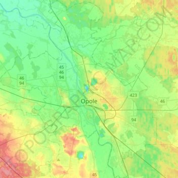
Nom : Carte topographique Opole, altitude, relief.
Lieu : Opole, Opole Voivodeship, Poland (50.58762 17.77959 50.76997 18.03269)
Altitude moyenne : 161 m
Altitude minimum : 138 m
Altitude maximum : 206 m
Autres cartes topographiques
Cliquez sur une carte pour visualiser sa topographie, son altitude et son relief.
Jezioro Nyskie
Poland > Opole Voivodeship > Nysa County > Siestrzechowice
Jezioro Nyskie, Siestrzechowice, gmina Nysa, Nysa County, Opole Voivodeship, Poland
Altitude moyenne : 202 m
Dekanat Ujazd Śląski
Poland > Opole Voivodeship > Strzelce County
Dekanat Ujazd Śląski, Strzelce County, Metropolis GZM, Opole Voivodeship, Poland
Altitude moyenne : 231 m
Nysa
Poland > Opole Voivodeship > Nysa County
Nysa, gmina Nysa, Nysa County, Opole Voivodeship, Poland
Altitude moyenne : 202 m
Gorzów Śląski
Poland > Opole Voivodeship > Olesno County
Gorzów Śląski, gmina Gorzów Śląski, Olesno County, Opole Voivodeship, 46-310, Poland
Altitude moyenne : 205 m
Krapkowice
Poland > Opole Voivodeship > Krapkowice County
Krapkowice, gmina Krapkowice, Krapkowice County, Opole Voivodeship, Poland
Altitude moyenne : 170 m
Głubczyce
Poland > Opole Voivodeship > Głubczyce County
Głubczyce, gmina Głubczyce, Głubczyce County, Opole Voivodeship, 48-100, Poland
Altitude moyenne : 274 m
Praszka
Poland > Opole Voivodeship > Olesno County
Praszka, gmina Praszka, Olesno County, Opole Voivodeship, 46-320, Poland
Altitude moyenne : 197 m
Stare Olesno
Poland > Opole Voivodeship > Olesno County
Stare Olesno, gmina Olesno, Olesno County, Opole Voivodeship, 46-300, Poland
Altitude moyenne : 218 m
Makowice
Poland > Opole Voivodeship > Nysa County
Makowice, gmina Skoroszyce, Nysa County, Opole Voivodeship, Poland
Altitude moyenne : 192 m
Namysłów
Poland > Opole Voivodeship > Namysłów County > Namysłów
Namysłów, gmina Namysłów, Namysłów County, Opole Voivodeship, Poland
Altitude moyenne : 160 m
Strzelce Opolskie
Poland > Opole Voivodeship > Strzelce County > Strzelce Opolskie > Strzelce Opolskie
Strzelce Opolskie, gmina Strzelce Opolskie, Strzelce County, Opole Voivodeship, 47-100, Poland
Altitude moyenne : 238 m
Góra Świętej Anny
Poland > Opole Voivodeship > Strzelce County > Góra Świętej Anny
Góra Świętej Anny, gmina Leśnica, Strzelce County, Opole Voivodeship, 47-154, Poland
Altitude moyenne : 321 m
Opole County
Opole County, Opole Voivodeship, Poland
Altitude moyenne : 192 m
Ujazd
Poland > Opole Voivodeship > Strzelce County > Ujazd > Ujazd
Ujazd, gmina Ujazd, Strzelce County, Opole Voivodeship, 47-143, Poland
Altitude moyenne : 212 m
Krasiejów
Poland > Opole Voivodeship > Opole County > Krasiejów
Krasiejów, gmina Ozimek, Opole County, Opole Voivodeship, Poland
Altitude moyenne : 189 m
Niemodlin
Poland > Opole Voivodeship > Niemodlin
Niemodlin, gmina Niemodlin, Opole County, Opole Voivodeship, 49-100, Poland
Altitude moyenne : 170 m
Strzelce County
Strzelce County, Opole Voivodeship, Poland
Altitude moyenne : 210 m
Prudnik
Poland > Opole Voivodeship > Prudnik
Prudnik, gmina Prudnik, Prudnik County, Opole Voivodeship, 48-200, Poland
Altitude moyenne : 282 m
Narok
Poland > Opole Voivodeship > Opole County
Narok, gmina Dąbrowa, Opole County, Opole Voivodeship, Poland
Altitude moyenne : 149 m
Biała
Poland > Opole Voivodeship > Biała
Biała, gmina Biała, powiat prudnicki, Opole Voivodeship, Poland
Altitude moyenne : 234 m
Kamień Śląski
Poland > Opole Voivodeship > Kamień Śląski
Kamień Śląski, gmina Izbicko, powiat strzelecki, Opole Voivodeship, 47-180, Poland
Altitude moyenne : 194 m
Łambinowice
Poland > Opole Voivodeship > Nysa County
Łambinowice, gmina Łambinowice, Nysa County, Opole Voivodeship, 48-316, Poland
Altitude moyenne : 198 m