
Faire un don
Équipez-vous pour votre prochaine aventure :
En tant que Partenaire Amazon, ce site perçoit une commission sur les achats éligibles sans surcoût pour vous.
Carte topographique Duntroon
Cliquez sur la carte pour afficher l’altitude.
Faire un don
Équipez-vous pour votre prochaine aventure :
En tant que Partenaire Amazon, ce site perçoit une commission sur les achats éligibles sans surcoût pour vous.
À propos de cette carte
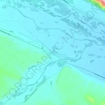
Nom : Carte topographique Duntroon, altitude, relief.
Lieu : Duntroon, Waitaki District, Canterbury, New Zealand (-44.87384 170.66321 -44.83384 170.70321)
Altitude moyenne : 150 m
Altitude minimum : 123 m
Altitude maximum : 379 m
Faire un don
Équipez-vous pour votre prochaine aventure :
En tant que Partenaire Amazon, ce site perçoit une commission sur les achats éligibles sans surcoût pour vous.
Autres cartes topographiques
Cliquez sur une carte pour visualiser sa topographie, son altitude et son relief.
Lake Ōhau
New Zealand > Canterbury > Waitaki District
Wilding Pines (Pinus Cortorta, Pinus sylvestris) are problematic on the foreshore of Lake Ōhau. Pinus contorta grow “probably five to 10 times faster” in the Mackenzie Country (and Lake Ōhau) than in their native North America. They can establish themselves at altitudes of up to 2000 metres. Where they…
Altitude moyenne : 904 m