
Carte topographique Genoa
Carte interactive
Cliquez sur la carte pour afficher l’altitude.
À propos de cette carte
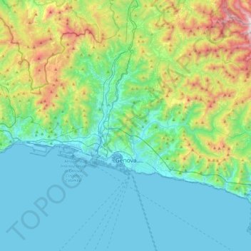
Nom : Carte topographique Genoa, altitude, relief.
Lieu : Genoa, Liguria, Italy (44.37847 8.66574 44.51984 9.09558)
Altitude moyenne : 333 m
Altitude minimum : -4 m
Altitude maximum : 1 525 m
The city of Genoa covers an area of 243 square kilometres (94 sq mi) between the Ligurian Sea and the Apennine Mountains. The city stretches along the coast for about 30 kilometres (19 mi) from the neighbourhood of Voltri to Nervi, and for 10 kilometres (6.2 mi) from the coast to the north along the valleys Polcevera and Bisagno. The territory of Genoa is popularly divided into 5 main zones: the centre, the west, the east, the Polcevera and the Bisagno Valley. Although much of the city centre is located at a low elevation, the territory surrounding it is mountainous with undeveloped land usually being in steep terrain.
Autres cartes topographiques
Cliquez sur une carte pour visualiser sa topographie, son altitude et son relief.
Montelungo
Italy > Liguria > Genoa > Genoa
Montelungo, Media Val Bisagno, Genoa, Liguria, 16165, Italy
Altitude moyenne : 282 m
Spianata dell'Acquasola
Italy > Liguria > Genoa > Genoa
Spianata dell'Acquasola, San Vincenzo, Centro Est, Genoa, Liguria, Italy
Altitude moyenne : 43 m
Mileto
Italy > Liguria > Genoa > Rezzoaglio
Mileto, Rezzoaglio, Genoa, Liguria, 16048, Italy
Altitude moyenne : 954 m