Géolocaliser

Carte topographique Windberg

Cliquez sur la carte pour afficher l’altitude.

À propos de cette carte

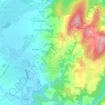
Nom : Carte topographique Windberg, altitude, relief.

Lieu : Windberg, Hunderdorf (VGem), Landkreis Straubing-Bogen, Bayern, Deutschland (48.93028 12.73604 48.96275 12.79007)

Altitude moyenne : 405 m

Altitude minimum : 324 m

Altitude maximum : 593 m

Autres cartes topographiques

Cliquez sur une carte pour visualiser sa topographie, son altitude et son relief.

Reißing

Deutschland > Bayern > Landkreis Straubing-Bogen

Altitude moyenne : 376 m

Hub

Deutschland > Bayern > Landkreis Straubing-Bogen > Wiesenfelden

Altitude moyenne : 578 m

Bogen

Deutschland > Bayern > Landkreis Straubing-Bogen

Altitude moyenne : 332 m

Ehren

Deutschland > Bayern > Landkreis Straubing-Bogen

Altitude moyenne : 384 m

Pillnach

Deutschland > Bayern > Landkreis Straubing-Bogen

Altitude moyenne : 352 m

Allkofen

Deutschland > Bayern > Landkreis Straubing-Bogen

Altitude moyenne : 380 m

Bogenberg

Deutschland > Bayern > Landkreis Straubing-Bogen > Bogen

Altitude moyenne : 327 m

Steinburg

Deutschland > Bayern > Landkreis Straubing-Bogen

Altitude moyenne : 394 m

Metting

Deutschland > Bayern > Landkreis Straubing-Bogen

Altitude moyenne : 388 m

Geraszell

Deutschland > Bayern > Landkreis Straubing-Bogen

Altitude moyenne : 633 m

Kößnach

Deutschland > Bayern > Landkreis Straubing-Bogen

Altitude moyenne : 320 m

Radldorf

Deutschland > Bayern > Landkreis Straubing-Bogen

Altitude moyenne : 340 m

Fahrndorf

Deutschland > Bayern > Landkreis Straubing-Bogen > Loham

Altitude moyenne : 317 m

Loham

Deutschland > Bayern > Landkreis Straubing-Bogen

Altitude moyenne : 316 m

Gallner

Deutschland > Bayern > Landkreis Straubing-Bogen > Konzell

Altitude moyenne : 477 m

Bärndorf

Deutschland > Bayern > Landkreis Straubing-Bogen

Altitude moyenne : 344 m

Hilm

Deutschland > Bayern > Landkreis Straubing-Bogen

Altitude moyenne : 746 m

Saulburg

Deutschland > Bayern > Landkreis Straubing-Bogen

Altitude moyenne : 428 m

Saulburg

Deutschland > Bayern > Landkreis Straubing-Bogen

Altitude moyenne : 428 m

Weichs

Deutschland > Bayern > Landkreis Straubing-Bogen

Altitude moyenne : 396 m

Équipez-vous pour votre prochaine aventure :

🧥Vestes polaires - Isolation thermique pour activités outdoor
🥾Chaussures de randonnée - Chaussures robustes pour la randonnée et les terrains accidentés
🧦Chaussettes de randonnée - Chaussettes techniques pour longues marches
🧥Doudounes outdoor - Chaleur et légèreté en conditions froides
Couverture de survie thermique - Sac de bivouac d'urgence pour conserver la chaleur corporelle

En tant que Partenaire Amazon, ce site perçoit une commission sur les achats éligibles sans surcoût pour vous.