
Carte topographique Krishnarajanagara
Carte interactive
Cliquez sur la carte pour afficher l’altitude.
À propos de cette carte
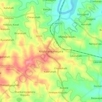
Nom : Carte topographique Krishnarajanagara, altitude, relief.
Altitude moyenne : 786 m
Altitude minimum : 747 m
Altitude maximum : 833 m
Krishnarajanagara is located on the northern part of Mysore district, west of the Krishna Raja Sagara Reservoir. It has an average elevation of 786 metres above sea level. NH-373, also known as SH-57 passes through the town of K.R.Nagara.