
Carte topographique Cuernavaca
Carte interactive
Cliquez sur la carte pour afficher l’altitude.
À propos de cette carte
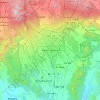
Nom : Carte topographique Cuernavaca, altitude, relief.
Lieu : Cuernavaca, Morelos, 62000, Mexico (18.76183 -99.39423 19.08183 -99.07423)
Altitude moyenne : 1 822 m
Altitude minimum : 965 m
Altitude maximum : 3 679 m
The city is located in a tropical region, but its temperature is fairly constant at 21–26 °C (70–79 °F). It is located on the southern slope of the Sierra de Chichinautzin mountains. In the morning, warm air flows up the mountains from the valley below and in the late afternoon, cooler air flows down from the higher elevations. One ubiquitous flowering plant in the city is the bougainvillea.
Autres cartes topographiques
Cliquez sur une carte pour visualiser sa topographie, son altitude et son relief.
Tetela Del Monte
Mexico > Morelos > Cuernavaca
Tetela Del Monte, Cuernavaca, Morelos, 62130, Mexico
Altitude moyenne : 1 821 m