
Carte topographique Saint Stephen
Carte interactive
Cliquez sur la carte pour afficher l’altitude.
À propos de cette carte
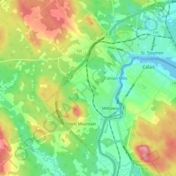
Nom : Carte topographique Saint Stephen, altitude, relief.
Lieu : Saint Stephen, Charlotte County, New Brunswick, Canada (45.14856 -67.33039 45.21269 -67.25827)
Altitude moyenne : 44 m
Altitude minimum : -2 m
Altitude maximum : 113 m
Autres cartes topographiques
Cliquez sur une carte pour visualiser sa topographie, son altitude et son relief.
St. Stephen
Canada > New Brunswick > Charlotte County > St. Stephen
St. Stephen, Charlotte County, New Brunswick, E3L 2K2, Canada
Altitude moyenne : 72 m
Great Duck Island
Canada > New Brunswick > Charlotte County
Great Duck Island, Village of Grand Manan, Charlotte County, New Brunswick, Canada
Altitude moyenne : 0 m
Deer Island
Canada > New Brunswick > Charlotte County > Deer Island
Deer Island, West Isles Parish, Charlotte County, New Brunswick, E5V 1W2, Canada
Altitude moyenne : 9 m