
Carte topographique Ruang
Carte interactive
Cliquez sur la carte pour afficher l’altitude.
À propos de cette carte
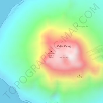
Nom : Carte topographique Ruang, altitude, relief.
Altitude moyenne : 274 m
Altitude minimum : 0 m
Altitude maximum : 724 m
Ruang is the southernmost stratovolcano in the Sangihe Islands arc, North Sulawesi, Indonesia. It comprises an island 4 by 5 kilometres (2.5 mi × 3.1 mi) wide. The summit contains a partial lava dome and reaches some 725 metres (2,379 ft) in altitude. From its summit, Klabat's peak in the south, that of Siau to the north, and Ternate to the east can all be seen.