
Carte topographique Prévonloup
Carte interactive
Cliquez sur la carte pour afficher l’altitude.
À propos de cette carte
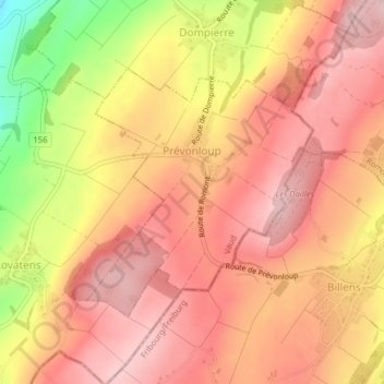
Nom : Carte topographique Prévonloup, altitude, relief.
Lieu : Prévonloup, District de la Broye-Vully, Vaud, Switzerland (46.68818 6.87115 46.70561 6.89446)
Altitude moyenne : 744 m
Altitude minimum : 606 m
Altitude maximum : 809 m
Autres cartes topographiques
Cliquez sur une carte pour visualiser sa topographie, son altitude et son relief.
Forel-sur-Lucens
Switzerland > Vaud > District de la Broye-Vully
Forel-sur-Lucens, Lucens, District de la Broye-Vully, Vaud, 1526, Switzerland
Altitude moyenne : 672 m
La Broye
Switzerland > Vaud > District de la Broye-Vully
La Broye, District de la Broye-Vully, Vaud, 1530, Switzerland
Altitude moyenne : 735 m
Payerne
Switzerland > Vaud > District de la Broye-Vully > Payerne
Payerne, District de la Broye-Vully, Vaud, Switzerland
Altitude moyenne : 495 m