
Carte topographique Pine Valley Mountain Wilderness
Carte interactive
Cliquez sur la carte pour afficher l’altitude.
À propos de cette carte
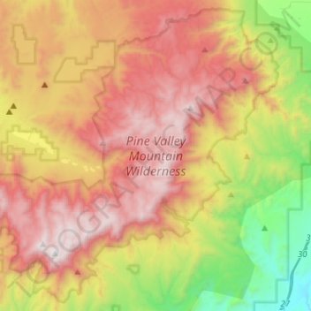
Nom : Carte topographique Pine Valley Mountain Wilderness, altitude, relief.
Altitude moyenne : 2 125 m
Altitude minimum : 1 117 m
Altitude maximum : 3 147 m
Pine Valley Mountain Wilderness is a 50,232-acre (203.28 km2) wilderness area located in the Dixie National Forest in the U.S. state of Utah. It is the fourth-largest wilderness area located entirely within the state (following the High Uintas Wilderness, Zion Wilderness, and Cedar Mountain Wilderness). The wilderness designation protects the Pine Valley Mountain range, a large rock outcrop surrounded by desert. The Pine Valley Mountains form the Pine Valley Laccolith, one of the largest laccoliths in the United States. Elevations in the wilderness range from 6,000 feet (1,800 m) to 10,365 feet (3,159 m) at the summit of Signal Peak.
Autres cartes topographiques
Cliquez sur une carte pour visualiser sa topographie, son altitude et son relief.
Springdale
United States > Utah > Washington County
Springdale, Washington County, Utah, 84767, United States
Altitude moyenne : 1 354 m
Saint George
United States > Utah > Washington County
Saint George, Washington County, Utah, United States
Altitude moyenne : 929 m
Cottonwood Canyon Wilderness
United States > Utah > Washington County > Washington
Cottonwood Canyon Wilderness, Washington, Washington County, Utah, United States
Altitude moyenne : 1 213 m
Toquerville
United States > Utah > Washington County
Toquerville, Washington County, Utah, 84774, United States
Altitude moyenne : 1 301 m
Hurricane
United States > Utah > Washington County
Hurricane, Washington County, Utah, United States
Altitude moyenne : 1 154 m
Ivins
United States > Utah > Washington County > Ivins
Ivins, Washington County, Utah, 84738, United States
Altitude moyenne : 1 007 m
Zion National Park
United States > Utah > Washington County
Zion National Park, Washington County, Utah, United States
Altitude moyenne : 1 877 m