
Carte topographique Ribeirão Preto
Carte interactive
Cliquez sur la carte pour afficher l’altitude.
À propos de cette carte
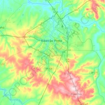
Nom : Carte topographique Ribeirão Preto, altitude, relief.
Altitude moyenne : 612 m
Altitude minimum : 497 m
Altitude maximum : 850 m
Ribeirão Preto is the eighth-largest municipality in the State with 650.9 km2 (251.3 sq mi). It has an estimated population of 720,216 in 2021 and a metropolitan area of 1,178,910. It is located 313 km (194 mi) from the city of São Paulo and 706 km (439 mi) from Brasília, the federal capital. Its mean altitude is 526.8 m (1,728 ft) high. The city's average temperature throughout the year is 23 °C (73 °F), and the original predominant vegetation is the Atlantic forest.
Autres cartes topographiques
Cliquez sur une carte pour visualiser sa topographie, son altitude et son relief.
Jaboticabal
Brazil > São Paulo > Região Metropolitana de Ribeirão Preto
Jaboticabal, Região Imediata de Ribeirão Preto, Região Metropolitana de Ribeirão Preto, Região Geográfica Intermediária de Ribeirão Preto, São Paulo, Southeast Region, Brazil
Altitude moyenne : 594 m
Dumont
Brazil > São Paulo > Região Metropolitana de Ribeirão Preto
Dumont, Região Imediata de Ribeirão Preto, Região Metropolitana de Ribeirão Preto, Região Geográfica Intermediária de Ribeirão Preto, São Paulo, Southeast Region, 14120-000, Brazil
Altitude moyenne : 605 m