
Carte topographique Town of Spooner
Carte interactive
Cliquez sur la carte pour afficher l’altitude.
À propos de cette carte
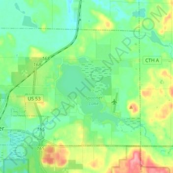
Nom : Carte topographique Town of Spooner, altitude, relief.
Altitude moyenne : 342 m
Altitude minimum : 315 m
Altitude maximum : 405 m
Autres cartes topographiques
Cliquez sur une carte pour visualiser sa topographie, son altitude et son relief.
Devils Lake
United States > Wisconsin > Washburn County
Devils Lake, Town of Bass Lake, Washburn County, Wisconsin, United States
Altitude moyenne : 367 m
Tomahawk Lake
United States > Wisconsin > Washburn County
Tomahawk Lake, Town of Casey, Washburn County, Wisconsin, United States
Altitude moyenne : 318 m
Slim Lake
United States > Wisconsin > Washburn County
Slim Lake, Town of Birchwood, Washburn County, Wisconsin, United States
Altitude moyenne : 404 m
Chicog Lake
United States > Wisconsin > Washburn County
Chicog Lake, Town of Chicog, Washburn County, Wisconsin, United States
Altitude moyenne : 314 m
Spooner
United States > Wisconsin > Washburn County
Spooner, Washburn County, Wisconsin, United States
Altitude moyenne : 336 m
Town of Chicog
United States > Wisconsin > Washburn County
Town of Chicog, Washburn County, Wisconsin, United States
Altitude moyenne : 310 m
Minong
United States > Wisconsin > Washburn County
Minong, Washburn County, Wisconsin, United States
Altitude moyenne : 330 m
Crystal Mountain
United States > Wisconsin > Washburn County
Crystal Mountain, Town of Spooner, Washburn County, Wisconsin, United States
Altitude moyenne : 344 m
Shell Lake
United States > Wisconsin > Washburn County
Shell Lake, Washburn County, Wisconsin, 53871, United States
Altitude moyenne : 376 m
Stone Lake
United States > Wisconsin > Washburn County
Stone Lake, Town of Stone Lake, Washburn County, Wisconsin, 54876, United States
Altitude moyenne : 405 m