
Carte topographique Araguari
Carte interactive
Cliquez sur la carte pour afficher l’altitude.
Araguari
Araguari is a municipality in western Minas Gerais state, Brazil. It is in the northern Triângulo Mineiro region, on the Jordão River, a tributary of the Paranaíba River, at an elevation between 940 and 1,087 metres (3,084 and 3,566 ft). The municipality of Araguari has an area of 2,774 km2 (1,071 sq mi), with 54 km2 (21 sq mi) in the urban zone and 2,675 km2 (1,033 sq mi) in the rural zone. The population in 2018 was 116,691, making it the third-most important city in the Triângulo Mineiro, after Uberlândia and Uberaba. Araguari has also been one of the fastest-growing cities in Brazil, growing more than the rest of the country in proportion.
À propos de cette carte
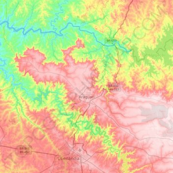
Nom : Carte topographique Araguari, altitude, relief.
Altitude moyenne : 755 m
Altitude minimum : 502 m
Altitude maximum : 1 019 m