
Faire un don
Équipez-vous pour votre prochaine aventure :
En tant que Partenaire Amazon, ce site perçoit une commission sur les achats éligibles sans surcoût pour vous.
Carte topographique Southland District
Cliquez sur la carte pour afficher l’altitude.
Faire un don
Équipez-vous pour votre prochaine aventure :
En tant que Partenaire Amazon, ce site perçoit une commission sur les achats éligibles sans surcoût pour vous.
À propos de cette carte
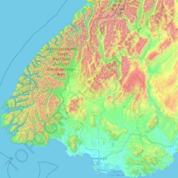
Nom : Carte topographique Southland District, altitude, relief.
Lieu : Southland District, Southland, New Zealand (-47.29000 166.42555 -44.25512 169.27947)
Altitude moyenne : 317 m
Altitude minimum : -2 m
Altitude maximum : 2 681 m
Faire un don
Équipez-vous pour votre prochaine aventure :
En tant que Partenaire Amazon, ce site perçoit une commission sur les achats éligibles sans surcoût pour vous.
Autres cartes topographiques
Cliquez sur une carte pour visualiser sa topographie, son altitude et son relief.
Riverton
New Zealand > Southland > Southland District > Oraka Aparima Community
Altitude moyenne : 16 m
Faire un don
Équipez-vous pour votre prochaine aventure :
En tant que Partenaire Amazon, ce site perçoit une commission sur les achats éligibles sans surcoût pour vous.
Roslyn Bush
New Zealand > Southland > Southland District > Waihopai Toetoe Community
Altitude moyenne : 29 m
Nightcaps
New Zealand > Southland > Southland District > Wallace Takitimu Community
Altitude moyenne : 183 m
Faire un don
Équipez-vous pour votre prochaine aventure :
En tant que Partenaire Amazon, ce site perçoit une commission sur les achats éligibles sans surcoût pour vous.
Clifden
New Zealand > Southland > Southland District > Tuatapere Te Waewae Community
Altitude moyenne : 70 m
Edendale
New Zealand > Southland > Southland District > Waihopai Toetoe Community
Altitude moyenne : 41 m
Pukemaori
New Zealand > Southland > Southland District > Tuatapere Te Waewae Community
Altitude moyenne : 124 m
Faire un don
Équipez-vous pour votre prochaine aventure :
En tant que Partenaire Amazon, ce site perçoit une commission sur les achats éligibles sans surcoût pour vous.
Makarewa Junction
New Zealand > Southland > Southland District > Oreti Community
Altitude moyenne : 17 m
Faire un don
Équipez-vous pour votre prochaine aventure :
En tant que Partenaire Amazon, ce site perçoit une commission sur les achats éligibles sans surcoût pour vous.
Otahu Flat
New Zealand > Southland > Southland District > Tuatapere Te Waewae Community
Altitude moyenne : 90 m
Faire un don
Équipez-vous pour votre prochaine aventure :
En tant que Partenaire Amazon, ce site perçoit une commission sur les achats éligibles sans surcoût pour vous.
Tūātapere
New Zealand > Southland > Southland District > Tuatapere Te Waewae Community
Altitude moyenne : 41 m
Mount Tūtoko
New Zealand > Southland > Southland District > Fiordland Community
Altitude moyenne : 1 892 m
Mount Anglem / Hananui
New Zealand > Southland > Southland District > Stewart Island / Rakiura Community
Mount Anglem / Hananui is the highest point on New Zealand's Stewart Island / Rakiura. It is located 20 kilometres (12 mi) northwest of Oban, close to the island's north coast, and rises to an elevation of 980 metres (3,215 ft) above sea level. Following the passage of the Ngāi Tahu Claims Settlement Act…
Altitude moyenne : 668 m
Mitre Peak
New Zealand > Southland > Southland District > Fiordland Community
Altitude moyenne : 657 m
Faire un don
Équipez-vous pour votre prochaine aventure :
En tant que Partenaire Amazon, ce site perçoit une commission sur les achats éligibles sans surcoût pour vous.
Mount Christina
New Zealand > Southland > Southland District > Fiordland Community
Altitude moyenne : 1 574 m
Takitimu Mountains
New Zealand > Southland > Southland District > Wallace Takitimu Community
Altitude moyenne : 828 m
Faire un don
Équipez-vous pour votre prochaine aventure :
En tant que Partenaire Amazon, ce site perçoit une commission sur les achats éligibles sans surcoût pour vous.
Te Puhi-a-noa / Murchison Mountains
New Zealand > Southland > Southland District
Altitude moyenne : 851 m
Darran Mountains
New Zealand > Southland > Southland District > Fiordland Community
Altitude moyenne : 911 m
Skippers Range
New Zealand > Southland > Southland District > Fiordland Community
Altitude moyenne : 595 m
Faire un don
Équipez-vous pour votre prochaine aventure :
En tant que Partenaire Amazon, ce site perçoit une commission sur les achats éligibles sans surcoût pour vous.
Te Rau / Garvie Mountains
New Zealand > Southland > Southland District > Cromwell Community
Altitude moyenne : 1 393 m
Wick Mountains
New Zealand > Southland > Southland District > Fiordland Community
Altitude moyenne : 1 185 m
Faire un don
Équipez-vous pour votre prochaine aventure :
En tant que Partenaire Amazon, ce site perçoit une commission sur les achats éligibles sans surcoût pour vous.
Tapuae-o-Uenuku / Hector Mountains
New Zealand > Southland > Queenstown-Lakes District
The foothills of the Hector Mountains were also significant to early Pākehā. The range was largely affected by the Otago gold rush of the 1860s, which saw miners flock to the Nevis in search of gold and a small town established in the foothills of the range. Sluicing sites are found along the eastern end of…
Altitude moyenne : 1 087 m
Mararoa River
New Zealand > Southland > Southland District > Fiordland Community
Altitude moyenne : 681 m
Waikawa River
New Zealand > Southland > Southland District > Waihopai Toetoe Community
Altitude moyenne : 134 m
Faire un don
Équipez-vous pour votre prochaine aventure :
En tant que Partenaire Amazon, ce site perçoit une commission sur les achats éligibles sans surcoût pour vous.
Lake Quill
New Zealand > Southland > Southland District > Fiordland Community
Altitude moyenne : 1 228 m
Lake Te Au
New Zealand > Southland > Southland District > Fiordland Community
Altitude moyenne : 597 m
Age Glacier
New Zealand > Southland > Southland District > Fiordland Community
Altitude moyenne : 1 753 m
Faire un don
Équipez-vous pour votre prochaine aventure :
En tant que Partenaire Amazon, ce site perçoit une commission sur les achats éligibles sans surcoût pour vous.
Pembroke Glacier
New Zealand > Southland > Southland District > Fiordland Community
Altitude moyenne : 1 211 m
Faire un don
Équipez-vous pour votre prochaine aventure :
En tant que Partenaire Amazon, ce site perçoit une commission sur les achats éligibles sans surcoût pour vous.
Oban
New Zealand > Southland > Southland District > Stewart Island / Rakiura Community
Altitude moyenne : 23 m
Mount Elliot
New Zealand > Southland > Southland District > Fiordland Community
Altitude moyenne : 1 110 m
Waimānu / Stirling Falls
New Zealand > Southland > Southland District > Fiordland Community
Altitude moyenne : 423 m
Faire un don
Équipez-vous pour votre prochaine aventure :
En tant que Partenaire Amazon, ce site perçoit une commission sur les achats éligibles sans surcoût pour vous.
Nightcaps
New Zealand > Southland > Southland District > Wallace Takitimu Community
Altitude moyenne : 183 m
Lake Innes
New Zealand > Southland > Southland District > Tuatapere Te Waewae Community
Altitude moyenne : 223 m
Faire un don
Équipez-vous pour votre prochaine aventure :
En tant que Partenaire Amazon, ce site perçoit une commission sur les achats éligibles sans surcoût pour vous.
Eldrig Peak
New Zealand > Southland > Southland District > Fiordland Community
Altitude moyenne : 1 155 m
Oban
New Zealand > Southland > Southland District > Stewart Island / Rakiura Community
Altitude moyenne : 23 m
Hineteawa / Bowen Falls
New Zealand > Southland > Southland District > Fiordland Community
Altitude moyenne : 232 m
Faire un don
Équipez-vous pour votre prochaine aventure :
En tant que Partenaire Amazon, ce site perçoit une commission sur les achats éligibles sans surcoût pour vous.
Island Hill
New Zealand > Southland > Southland District > Stewart Island / Rakiura Community
Altitude moyenne : 50 m
Twin Sisters
New Zealand > Southland > Southland District > Fiordland Community
Altitude moyenne : 1 039 m
Faire un don
Équipez-vous pour votre prochaine aventure :
En tant que Partenaire Amazon, ce site perçoit une commission sur les achats éligibles sans surcoût pour vous.
Pearl Harbour
New Zealand > Southland > Southland District > Fiordland Community > Manapouri
Altitude moyenne : 212 m
Faire un don
Équipez-vous pour votre prochaine aventure :
En tant que Partenaire Amazon, ce site perçoit une commission sur les achats éligibles sans surcoût pour vous.
Merrivale
New Zealand > Southland > Southland District > Tuatapere Te Waewae Community
Altitude moyenne : 192 m
Mount Owen
New Zealand > Southland > Southland District > Fiordland Community
Altitude moyenne : 1 269 m
Sutherland Falls
New Zealand > Southland > Southland District > Fiordland Community
Altitude moyenne : 1 006 m
Faire un don
Équipez-vous pour votre prochaine aventure :
En tant que Partenaire Amazon, ce site perçoit une commission sur les achats éligibles sans surcoût pour vous.
Mitre Peak
New Zealand > Southland > Southland District > Fiordland Community
Altitude moyenne : 657 m
White Peak
New Zealand > Southland > Southland District > Tuatapere Te Waewae Community
Altitude moyenne : 1 153 m
Blackmount
New Zealand > Southland > Southland District > Tuatapere Te Waewae Community > Blackmount
Altitude moyenne : 170 m
Faire un don
Équipez-vous pour votre prochaine aventure :
En tant que Partenaire Amazon, ce site perçoit une commission sur les achats éligibles sans surcoût pour vous.
Waikawa
New Zealand > Southland > Southland District > Waihopai Toetoe Community > Waikawa
Altitude moyenne : 39 m
Faire un don
Équipez-vous pour votre prochaine aventure :
En tant que Partenaire Amazon, ce site perçoit une commission sur les achats éligibles sans surcoût pour vous.
Mount Makere
New Zealand > Southland > Southland District > Fiordland Community
Altitude moyenne : 1 433 m
Turner Falls
New Zealand > Southland > Southland District > Fiordland Community
Altitude moyenne : 1 335 m
The Downs
New Zealand > Southland > Southland District > Tuatapere Te Waewae Community
Altitude moyenne : 34 m
Faire un don
Équipez-vous pour votre prochaine aventure :
En tant que Partenaire Amazon, ce site perçoit une commission sur les achats éligibles sans surcoût pour vous.