
Carte topographique Speckled Wood, Hastings
Carte interactive
Cliquez sur la carte pour afficher l’altitude.
Speckled Wood, Hastings
The Upper Ore Valley to date has steep sixty-degree valleys or inclines to the north, east and west. The stream cuts right through the lower valley exposing the Ashdown bed in sections along the valley floor. To the west the incline falls off to a plateau which then rises to land level. The North End of the Upper Valley has been topographically mapped to reveal its slopes. This was created by a group of volunteers that made a model from MDF based on height readings from the Valley floor. The ghyll forms a link within the Hastings green corridor both spatially and as a means to prevent further fragmentation of flora and fauna.
À propos de cette carte
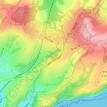
Nom : Carte topographique Speckled Wood, Hastings, altitude, relief.
Altitude moyenne : 92 m
Altitude minimum : 0 m
Altitude maximum : 173 m