
Carte topographique Carlingford
Carte interactive
Cliquez sur la carte pour afficher l’altitude.
À propos de cette carte
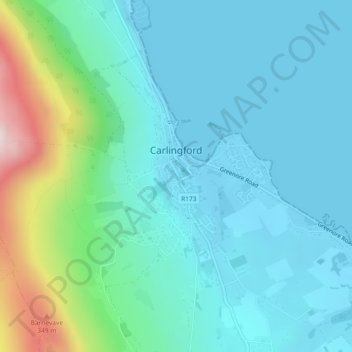
Nom : Carte topographique Carlingford, altitude, relief.
Lieu : Carlingford, County Louth, Leinster, Ireland (54.03068 -6.19431 54.04750 -6.17239)
Altitude moyenne : 84 m
Altitude minimum : -1 m
Altitude maximum : 433 m
Autres cartes topographiques
Cliquez sur une carte pour visualiser sa topographie, son altitude et son relief.
Broadlough
Broadlough, Ardee Rural ED, The Municipal District of Ardee, County Louth, Leinster, Ireland
Altitude moyenne : 34 m
Collon
Collon, Collon ED, The Municipal District of Ardee, County Louth, Leinster, Ireland
Altitude moyenne : 144 m
Dunleer
Dunleer, The Municipal District of Ardee, County Louth, Leinster, Ireland
Altitude moyenne : 40 m
Ballinteskin
Ballinteskin, Drummullagh ED, The Municipal District of Dundalk, County Louth, Leinster, Ireland
Altitude moyenne : 170 m
Grattanstown
Grattanstown, Dysart ED, The Municipal District of Ardee, County Louth, Leinster, Ireland
Altitude moyenne : 56 m
Dundalk
Ireland > County Louth > Dundalk
Dundalk, The Municipal District of Dundalk, County Louth, Leinster, A91 RC44, Ireland
Altitude moyenne : 16 m
Clogherhead
Clogherhead, County Louth, Leinster, Ireland
Altitude moyenne : 17 m
Rathcor
Rathcor, Rathcor ED, The Municipal District of Dundalk, County Louth, Leinster, Ireland
Altitude moyenne : 22 m
Drogheda
Ireland > County Louth > Drogheda
Drogheda, The Borough District of Drogheda, County Louth, Leinster, A92DKR0, Ireland
Altitude moyenne : 38 m
The Municipal District of Ardee
The Municipal District of Ardee, County Louth, Leinster, Ireland
Altitude moyenne : 45 m
Dundalk Poor Law Union
Dundalk Poor Law Union, County Louth, Leinster, Ireland
Altitude moyenne : 74 m
Drogheda Poor Law Union 1885
Drogheda Poor Law Union 1885, County Louth, Leinster, Ireland
Altitude moyenne : 53 m
Priest Town
Priest Town, Mullary ED, The Municipal District of Ardee, County Louth, Leinster, Ireland
Altitude moyenne : 105 m
Falmore
Falmore, Faughart ED, The Municipal District of Dundalk, County Louth, Leinster, Ireland
Altitude moyenne : 31 m
Dromiskin
Dromiskin, Dromiskin ED, The Municipal District of Dundalk, County Louth, Leinster, A91 RW01, Ireland
Altitude moyenne : 8 m
Brookville Park
Brookville Park, Fair Gate ED, The Borough District of Drogheda, County Louth, Leinster, Ireland
Altitude moyenne : 26 m
Carlingford
Ireland > County Louth > Carlingford
Carlingford, The Municipal District of Dundalk, County Louth, Leinster, A91 TRR6, Ireland
Altitude moyenne : 84 m
The Borough District of Drogheda
The Borough District of Drogheda, County Louth, Leinster, Ireland
Altitude moyenne : 50 m
Jenkinstown
Jenkinstown, Jenkinstown ED, The Municipal District of Dundalk, County Louth, Leinster, Ireland
Altitude moyenne : 111 m
Killeen
Killeen, Louth ED, The Municipal District of Ardee, County Louth, Leinster, Ireland
Altitude moyenne : 35 m
Collon
Ireland > County Louth > Collon
Collon, The Municipal District of Ardee, County Louth, Leinster, A92 K168, Ireland
Altitude moyenne : 146 m
Millgrange
Millgrange, Greenore ED, The Municipal District of Dundalk, County Louth, Leinster, Ireland
Altitude moyenne : 21 m
Lowrath North
Lowrath North, Louth ED, The Municipal District of Ardee, County Louth, Leinster, Ireland
Altitude moyenne : 35 m
Castletown
Castletown, Castletown ED, The Municipal District of Dundalk, County Louth, Leinster, Ireland
Altitude moyenne : 14 m
Monasterboice
Monasterboice, Monasterboice ED, The Borough District of Drogheda, County Louth, Leinster, Ireland
Altitude moyenne : 110 m
Greenmount
Greenmount, Castlebellingham ED, The Municipal District of Ardee, County Louth, Leinster, Ireland
Altitude moyenne : 18 m
Mountbagnall
Mountbagnall, Rathcor ED, The Municipal District of Dundalk, County Louth, Leinster, Ireland
Altitude moyenne : 24 m
Drumcashel
Drumcashel, Stabannan ED, The Municipal District of Ardee, County Louth, Leinster, Ireland
Altitude moyenne : 25 m
Marsh North
Marsh North, Dundalk Rural ED, The Municipal District of Dundalk, County Louth, Leinster, Ireland
Altitude moyenne : 3 m
Dromiskin
Ireland > County Louth > Dromiskin
Dromiskin, The Municipal District of Dundalk, County Louth, Leinster, A91 RW01, Ireland
Altitude moyenne : 8 m
Newtownstalaban
Newtownstalaban, St. Peter's ED, The Borough District of Drogheda, County Louth, Leinster, Ireland
Altitude moyenne : 20 m
Ballagan
Ballagan, Greenore ED, The Municipal District of Dundalk, County Louth, Leinster, Ireland
Altitude moyenne : 9 m
Mullincross
Mullincross, Castlebellingham ED, The Municipal District of Ardee, County Louth, Leinster, Ireland
Altitude moyenne : 20 m
Faughart
Faughart, The Municipal District of Dundalk, County Louth, Leinster, Ireland
Altitude moyenne : 55 m
Mullagharlin
Mullagharlin, Dundalk Rural ED, The Municipal District of Dundalk, County Louth, Leinster, Ireland
Altitude moyenne : 17 m
The Municipal District of Dundalk
The Municipal District of Dundalk, County Louth, Leinster, Ireland
Altitude moyenne : 68 m
Mullavally
Mullavally, Louth ED, The Municipal District of Ardee, County Louth, Leinster, Ireland
Altitude moyenne : 34 m
Tinure
Tinure, The Municipal District of Ardee, County Louth, Leinster, A92 V4Y2, Ireland
Altitude moyenne : 100 m