
Carte topographique Lake Garda
Carte interactive
Cliquez sur la carte pour afficher l’altitude.
À propos de cette carte
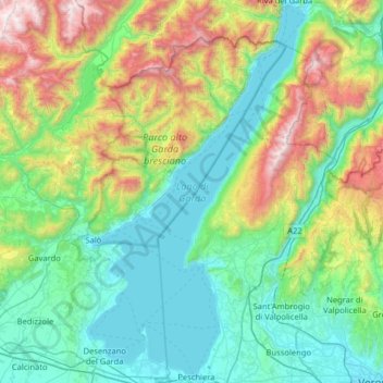
Nom : Carte topographique Lake Garda, altitude, relief.
Lieu : Lake Garda, Brescia, Lombardy, Italy (45.43775 10.51091 45.88482 10.87690)
Altitude moyenne : 571 m
Altitude minimum : 57 m
Altitude maximum : 2 211 m
The particularly mild climate favours the growth of some hardy Mediterranean plants, including the olive tree, parasol pine, mediterranean cypress, chinese windmill palm and Canary Island Date Palm. Some hardy citrus trees, such as hardy lemons and satsuma can also be found, which are extremely rare at this latitude (46° North). In ancient times, poets like Catullus wrote about "Lacus Benacus" with its mild climate vivified by the winds. The lake is oriented from north to south towards the Po Valley, so many winds typical of the lake are the result of a difference between lower and higher altitude temperatures. Due to this, winds are generated that descend from the mountains to the plains in the morning and go back to the mountains in the afternoon. The bottleneck formed by the lake basin affects the timing of the winds, many of which happen on a regular daily basis. The winds are all named, most in regional Italian dialect so a single wind may have different names.
Autres cartes topographiques
Cliquez sur une carte pour visualiser sa topographie, son altitude et son relief.