
Carte topographique Àird
Carte interactive
Cliquez sur la carte pour afficher l’altitude.
À propos de cette carte
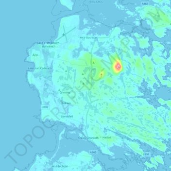
Nom : Carte topographique Àird, altitude, relief.
Lieu : Àird, Western Isles, Scotland, United Kingdom, Benbecula (57.39877 -7.41201 57.49401 -7.19778)
Altitude moyenne : 5 m
Altitude minimum : -4 m
Altitude maximum : 121 m
There is a dense cluster of lochs across almost the entire island, and almost all of the island is below 20 metres (70 feet) in elevation.
Autres cartes topographiques
Cliquez sur une carte pour visualiser sa topographie, son altitude et son relief.
Reef
United Kingdom > Scotland > Western Isles
Reef, Western Isles, Scotland, HS2 9HU, United Kingdom
Altitude moyenne : 18 m
Scarista
United Kingdom > Scotland > Western Isles
Scarista, Western Isles, Scotland, HS3 3HX, United Kingdom
Altitude moyenne : 60 m
Vatersay
United Kingdom > Scotland > Western Isles > Vatersay
Vatersay, Western Isles, Scotland, United Kingdom
Altitude moyenne : 19 m
Tong
United Kingdom > Scotland > Western Isles
Tong, Western Isles, Scotland, HS2 0HJ, United Kingdom
Altitude moyenne : 15 m
Tarbert
United Kingdom > Scotland > Western Isles
Tarbert, Western Isles, Scotland, HS3 3DB, United Kingdom
Altitude moyenne : 87 m
St Kilda
United Kingdom > Scotland > Western Isles
St Kilda, Western Isles, Scotland, United Kingdom
Altitude moyenne : 11 m