
Carte topographique Kutaisi
Carte interactive
Cliquez sur la carte pour afficher l’altitude.
À propos de cette carte
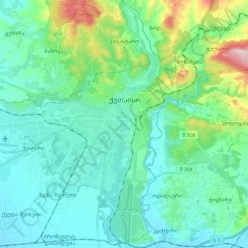
Nom : Carte topographique Kutaisi, altitude, relief.
Lieu : Kutaisi, Imereti, Georgia (42.19712 42.60616 42.32094 42.74188)
Altitude moyenne : 189 m
Altitude minimum : 93 m
Altitude maximum : 599 m
Kutaisi is located along both banks of the Rioni River. The city lies at an elevation of 125–300 metres (410–984 feet) above sea level. To the east and northeast, Kutaisi is bounded by the Northern Imereti Foothills, to the north by the Samgurali Range, and to the west and the south by the Colchis Plain.
Autres cartes topographiques
Cliquez sur une carte pour visualiser sa topographie, son altitude et son relief.
Tqibuli
Georgia > Imereti > Tqibuli Municipality
Tqibuli, Tqibuli Municipality, Imereti, Georgia
Altitude moyenne : 826 m
Baghdati Municipality
Baghdati Municipality, Imereti, 1000, Georgia
Altitude moyenne : 947 m
Samtredia
Georgia > Imereti > Samtredia Municipality
Samtredia, Samtredia Municipality, Imereti, 3900, Georgia
Altitude moyenne : 26 m
Sairme
Georgia > Imereti > Vani Municipality > Sairme
Sairme, Vani Municipality, Imereti, Georgia
Altitude moyenne : 1 279 m