

Carte topographique Kolhapur
Cliquez sur la carte pour afficher l’altitude.
Kolhapur
Kolhapur is an inland city located in south-west Maharashtra state, 385 km (239 mi) south of Mumbai and 237 km (147 mi) south of Pune, 656 km (408 mi) north-west of Bengaluru, 539 km (335 mi) west of Hyderabad and 49 km (30 mi) west of Sangli city. Within Maharashtra, Kolhapur's nearest cities and towns are Ichalkaranji 30 km (19 mi), Jaysingpur 40 km (25 mi), Kagal 20 km (12 mi), Belgaum 114 km (71 mi). It lies in the Sahayadri mountains in the Western Ghats at an elevation of 569 m (1,867 ft). Tambraparni river dam near Umgaon village is close by, as also are Radhanagari and Kalambawadi dams. Panhala 21 km (13 mi) and Jyotiba Temple 19 km (12 mi) are in the vicinity of Kolhapur too.
À propos de cette carte
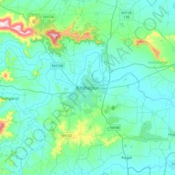
Nom : Carte topographique Kolhapur, altitude, relief.
Altitude moyenne : 592 m
Altitude minimum : 532 m
Altitude maximum : 971 m
Autres cartes topographiques
Cliquez sur une carte pour visualiser sa topographie, son altitude et son relief.
