Géolocaliser

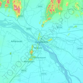
Carte topographique Vijayawada

Cliquez sur la carte pour afficher l’altitude.

Vijayawada

Vijayawada lies on the banks of Krishna river, covered by hills and canals. and at an altitude of 11 m (36 ft) above sea level. Three canals originating from the north side of the Prakasam Barrage reservoir — Eluru, Bandar, and Ryves — flow through the city.

Wikipedia (CC-BY-SA 3.0)

À propos de cette carte

Nom : Carte topographique Vijayawada, altitude, relief.

Lieu : Vijayawada, Vijayawada (Urban), NTR, Andhra Pradesh, 520001, India (16.35153 80.45605 16.67153 80.77605)

Altitude moyenne : 37 m

Altitude minimum : 7 m

Altitude maximum : 448 m

Équipez-vous pour votre prochaine aventure :

🍼Bouteille d'eau isotherme 1L - Maintient l'eau fraîche ou le thé chaud pendant des heures
🧢Chapeaux de randonnée - Protection solaire pour activités outdoor
❄️Crampons antidérapants - Adhérence sur neige et glace
🧂Spray anti-ours - Sécurité en zones sauvages canadiennes
Tentes légères - Tentes compactes pour trekking

En tant que Partenaire Amazon, ce site perçoit une commission sur les achats éligibles sans surcoût pour vous.