
Carte topographique Milpa Alta
Carte interactive
Cliquez sur la carte pour afficher l’altitude.
À propos de cette carte
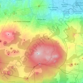
Nom : Carte topographique Milpa Alta, altitude, relief.
Lieu : Milpa Alta, Mexico City, Mexico (19.04872 -99.16329 19.22770 -98.95239)
Altitude moyenne : 2 842 m
Altitude minimum : 2 230 m
Altitude maximum : 3 673 m
It has an average altitude of 2,420 meters above sea level with altitudes varying between 2,300 and 3,600. It is part of the Trans-Mexican Volcanic Belt and the Sierra Chichinautzin volcanic mountain chain, which separates Mexico City from the state of Morelos. The borough is divided into three zones: Ajusco-Teuhtli, the lowest elevations, Topilejo-Milpa Alta in the medium range and Cerro-Tlicuaya at the highest elevations. The main elevations are volcanic and include Cuautzin (3,510), Tulmiac, Ocusacayo (3,220), La Comalera (3,230), San Bartolo (3,200), Tláloc (3,510), Chichinautzin (3,470), Yecahuazac, Quimixtepec, El Oclayuca (3,140), El Pajonal (3,100), El Ocotécatl (3,480), Acopiaxco (3,320), Tetzacoatl (3,310), Tehutli (2,800) Cilcuayo (3,580), Nepanapa (3,460), Texalo (3,560), Oclayuca (3,390), San Miguel (2,988) .
Autres cartes topographiques
Cliquez sur une carte pour visualiser sa topographie, son altitude et son relief.
Alameda Central
Alameda Central, Cuauhtémoc, Mexico City, Mexico
Altitude moyenne : 2 235 m
San Miguel Ajusco
San Miguel Ajusco, Mexico City, 14700, Mexico
Altitude moyenne : 2 939 m