
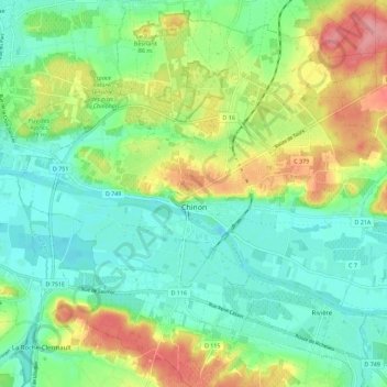
Carte topographique Chinon
Carte interactive
Cliquez sur la carte pour afficher l’altitude.
À propos de cette carte
Nom : Carte topographique Chinon, altitude, relief.
Altitude moyenne : 58 m
Altitude minimum : 24 m
Altitude maximum : 124 m
Topography has played a major role: the formerly fortified town was developed at the foot of the castle on the rocky outcrop, protecting the northern side, with the Vienne River in the south. Apart from the natural defensive protection on both sides, this fact makes a long narrow urban space, with the main streets running parallel to the river.
Autres cartes topographiques
Cliquez sur une carte pour visualiser sa topographie, son altitude et son relief.
Villeplate
France > Centre-Val de Loire > Indre-et-Loire > La Guerche
Villeplate, La Guerche, Loches, Indre-et-Loire, Centre-Val de Loire, Metropolitan France, 37350, France
Altitude moyenne : 81 m
Saché
France > Centre-Val de Loire > Indre-et-Loire
Saché, Tours, Indre-et-Loire, Centre-Val de Loire, Metropolitan France, 37190, France
Altitude moyenne : 86 m
Larçay
France > Centre-Val de Loire > Indre-et-Loire
Larçay, Tours, Indre-et-Loire, Centre-Val de Loire, Metropolitan France, 37270, France
Altitude moyenne : 81 m
La Boiselle
France > Centre-Val de Loire > Indre-et-Loire > Dierre
La Boiselle, Les Devants du Prieuré, Dierre, Loches, Indre-et-Loire, Centre-Val de Loire, Metropolitan France, 37150, France
Altitude moyenne : 76 m
Château-la-Vallière
France > Centre-Val de Loire > Indre-et-Loire
Château-la-Vallière, Chinon, Indre-et-Loire, Centre-Val de Loire, Metropolitan France, 37330, France
Altitude moyenne : 96 m
Le Bourg
France > Centre-Val de Loire > Indre-et-Loire > Cinq-Mars-la-Pile
Le Bourg, Cinq-Mars-la-Pile, Chinon, Indre-et-Loire, Centre-Val de Loire, Metropolitan France, 37130, France
Altitude moyenne : 62 m
Le Bourg
France > Centre-Val de Loire > Indre-et-Loire > Fondettes
Le Bourg, Fondettes, Tours, Indre-et-Loire, Centre-Val de Loire, Metropolitan France, 37230, France
Altitude moyenne : 83 m
Saint-Flovier
France > Centre-Val de Loire > Indre-et-Loire
Saint-Flovier, Loches, Indre-et-Loire, Centre-Val de Loire, Metropolitan France, 37600, France
Altitude moyenne : 135 m
Marcilly-sur-Vienne
France > Centre-Val de Loire > Indre-et-Loire
Marcilly-sur-Vienne, Chinon, Indre-et-Loire, Centre-Val de Loire, Metropolitan France, 37800, France
Altitude moyenne : 62 m
Le Bois Turbet
France > Centre-Val de Loire > Indre-et-Loire > Marcé-sur-Esves
Le Bois Turbet, Marcé-sur-Esves, Loches, Indre-et-Loire, Centre-Val de Loire, Metropolitan France, 37160, France
Altitude moyenne : 82 m
La Bérangerie
France > Centre-Val de Loire > Indre-et-Loire > Saint-Jean-Saint-Germain
La Bérangerie, Saint-Jean-Saint-Germain, Loches, Indre-et-Loire, Centre-Val de Loire, Metropolitan France, 37600, France
Altitude moyenne : 108 m
Descartes
France > Centre-Val de Loire > Indre-et-Loire
Descartes, Loches, Indre-et-Loire, Centre-Val de Loire, Metropolitan France, 37160, France
Altitude moyenne : 90 m
Tours
France > Centre-Val de Loire > Indre-et-Loire
Tours, Indre-et-Loire, Centre-Val de Loire, Metropolitan France, France
Altitude moyenne : 73 m
Amboise
France > Centre-Val de Loire > Indre-et-Loire
Amboise, Loches, Indre-et-Loire, Centre-Val de Loire, Metropolitan France, 37400, France
Altitude moyenne : 91 m
Ciran
France > Centre-Val de Loire > Indre-et-Loire
Ciran, Loches, Indre-et-Loire, Centre-Val de Loire, Metropolitan France, 37240, France
Altitude moyenne : 103 m
Varton
France > Centre-Val de Loire > Indre-et-Loire > Boussay
Varton, Boussay, Loches, Indre-et-Loire, Centre-Val de Loire, Metropolitan France, 37290, France
Altitude moyenne : 109 m