
Carte topographique Green Lake County
Carte interactive
Cliquez sur la carte pour afficher l’altitude.
À propos de cette carte
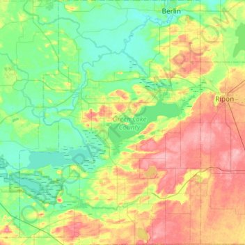
Nom : Carte topographique Green Lake County, altitude, relief.
Lieu : Green Lake County, Wisconsin, USA (43.63175 -89.24556 43.98357 -88.88511)
Altitude moyenne : 263 m
Altitude minimum : 228 m
Altitude maximum : 334 m
Autres cartes topographiques
Cliquez sur une carte pour visualiser sa topographie, son altitude et son relief.
Clare Island
USA > Wisconsin > Lake Delton
Clare Island, Lake Delton, Sauk County, Wisconsin, 53940, USA
Altitude moyenne : 288 m
Dodgeville
USA > Wisconsin > Dodgeville
Dodgeville, Iowa County, Wisconsin, USA
Altitude moyenne : 370 m
Gays Mills
USA > Wisconsin > Gays Mills
Gays Mills, Crawford County, Wisconsin, USA
Altitude moyenne : 272 m
WEVR-AM (River Falls)
WEVR-AM (River Falls), Radio Road, Glover, Town of Troy, Saint Croix County, Wisconsin, 54022, USA
Altitude moyenne : 301 m