
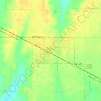
Carte topographique Goltry
Carte interactive
Cliquez sur la carte pour afficher l’altitude.
À propos de cette carte
Nom : Carte topographique Goltry, altitude, relief.
Lieu : Goltry, Alfalfa County, Oklahoma, 73739, United States (36.52845 -98.15793 36.53547 -98.14377)
Altitude moyenne : 419 m
Altitude minimum : 402 m
Altitude maximum : 429 m
Autres cartes topographiques
Cliquez sur une carte pour visualiser sa topographie, son altitude et son relief.
Helena
United States > Oklahoma > Alfalfa County
Helena, Alfalfa County, Oklahoma, 73741, United States
Altitude moyenne : 428 m
Carmen
United States > Oklahoma > Alfalfa County
Carmen, Alfalfa County, Oklahoma, 73726, United States
Altitude moyenne : 411 m
Aline
United States > Oklahoma > Alfalfa County
Aline, Alfalfa County, Oklahoma, United States
Altitude moyenne : 397 m
Jet
United States > Oklahoma > Alfalfa County
Jet, Alfalfa County, Oklahoma, 73749, United States
Altitude moyenne : 378 m