
Carte topographique Pienaars
Carte interactive
Cliquez sur la carte pour afficher l’altitude.
À propos de cette carte
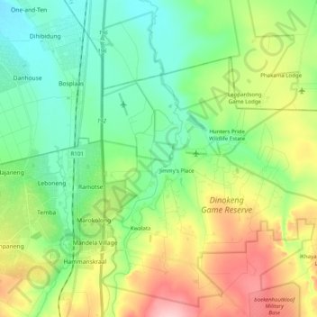
Nom : Carte topographique Pienaars, altitude, relief.
Altitude moyenne : 1 095 m
Altitude minimum : 1 040 m
Altitude maximum : 1 202 m
Autres cartes topographiques
Cliquez sur une carte pour visualiser sa topographie, son altitude et son relief.
Wonderboom Nature Reserve
Wonderboom Nature Reserve, Steve Biko Street, Tshwane Ward 54, Pretoria, City of Tshwane Metropolitan Municipality, Gauteng, 0116, RSA
Altitude moyenne : 1 277 m
Tshwane Ward 80
Tshwane Ward 80, Pretoria, City of Tshwane Metropolitan Municipality, Gauteng, RSA
Altitude moyenne : 1 357 m
Tshwane Ward 46
Tshwane Ward 46, Pretoria, City of Tshwane Metropolitan Municipality, Gauteng, RSA
Altitude moyenne : 1 396 m
Tshwane Ward 3
Tshwane Ward 3, Pretoria, City of Tshwane Metropolitan Municipality, Gauteng, RSA
Altitude moyenne : 1 399 m
Tshwane Ward 7
Tshwane Ward 7, Pretoria, City of Tshwane Metropolitan Municipality, Gauteng, RSA
Altitude moyenne : 1 367 m
Tshwane Ward 92
Tshwane Ward 92, Pretoria, City of Tshwane Metropolitan Municipality, Gauteng, RSA
Altitude moyenne : 1 351 m
Tshwane Ward 102
Tshwane Ward 102, Pretoria, City of Tshwane Metropolitan Municipality, Gauteng, RSA
Altitude moyenne : 1 472 m
Magaliesberg Nature Area
Magaliesberg Nature Area, Birdflower Road, Tshwane Ward 7, Pretoria, City of Tshwane Metropolitan Municipality, Gauteng, RSA
Altitude moyenne : 1 386 m
Tshwane Ward 56
Tshwane Ward 56, Pretoria, City of Tshwane Metropolitan Municipality, Gauteng, RSA
Altitude moyenne : 1 380 m
Tshwane Ward 55
Tshwane Ward 55, Pretoria, City of Tshwane Metropolitan Municipality, Gauteng, RSA
Altitude moyenne : 1 334 m
Tshwane Ward 44
Tshwane Ward 44, Pretoria, City of Tshwane Metropolitan Municipality, Gauteng, 0043, RSA
Altitude moyenne : 1 406 m
Tshwane Ward 84
Tshwane Ward 84, Pretoria, City of Tshwane Metropolitan Municipality, Gauteng, RSA
Altitude moyenne : 1 322 m